Geolocate

Bluebell Hill topographic map

Click on the map to display elevation.

About this map

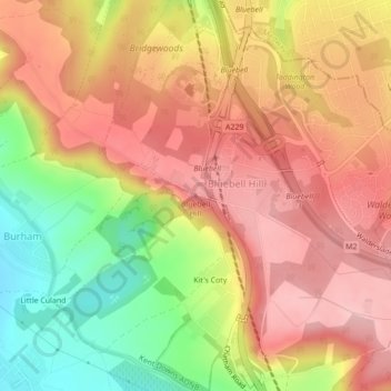
Name: Bluebell Hill topographic map, elevation, terrain.

Location: Bluebell Hill, Tonbridge and Malling, Kent, England, ME5 9RG, United Kingdom (51.33158 0.50136 51.33168 0.50146)

Average elevation: 129 m

Minimum elevation: 27 m

Maximum elevation: 198 m

Other topographic maps

Click on a map to view its topography, its elevation and its terrain.

Wrotham

United Kingdom > England > Kent > Tonbridge and Malling > Wrotham

Average elevation: 145 m

Offham

United Kingdom > England > Kent > Tonbridge and Malling

Average elevation: 96 m

Ryarsh

United Kingdom > England > Kent > Tonbridge and Malling

Average elevation: 57 m

Hadlow

United Kingdom > England > Kent > Tonbridge and Malling > Hadlow

Average elevation: 30 m

Ditton

United Kingdom > England > Kent > Tonbridge and Malling > Ditton

Average elevation: 37 m

Plaxtol

United Kingdom > England > Kent > Tonbridge and Malling

Average elevation: 100 m

Wouldham

United Kingdom > England > Kent > Tonbridge and Malling

Average elevation: 63 m

Ightham

United Kingdom > England > Kent > Tonbridge and Malling

Average elevation: 121 m

Mereworth

United Kingdom > England > Kent > Tonbridge and Malling

Average elevation: 104 m

Burham

United Kingdom > England > Kent > Tonbridge and Malling > Burham

Average elevation: 58 m

Hadlow

United Kingdom > England > Kent > Tonbridge and Malling

Average elevation: 30 m

Gear up for your next adventure:

🥾Light Trekking Boots - Supportive boots for multi-day treks
🥾Approach Shoes - Shoes designed for climbing approaches and rugged trails
💧Hydration Pack - Hands-free hydration system for long hikes
🛶Waterproof Dry Bags - Keep electronics and clothes dry during river crossings
🧦Merino Wool Socks - Moisture-wicking comfort for long-distance hiking

As an Amazon Associate, this site earns from qualifying purchases at no extra cost to you.