Geolocate

Fully topographic map

Click on the map to display elevation.

About this map

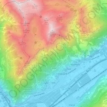
Name: Fully topographic map, elevation, terrain.

Location: Fully, Martigny, Wallis, 1926, Switzerland (46.12039 7.06866 46.20159 7.16604)

Average elevation: 1,390 m

Minimum elevation: 451 m

Maximum elevation: 2,950 m

Other topographic maps

Click on a map to view its topography, its elevation and its terrain.

Ly

Switzerland > Wallis > Martigny > Trient

Average elevation: 2,234 m

Dugny

Switzerland > Wallis > Martigny > Ovronnaz

Average elevation: 1,074 m

Le Guercet

Switzerland > Wallis > Martigny > Martigny

Average elevation: 718 m

La Tzoumaz

Switzerland > Wallis > Martigny

Average elevation: 1,467 m

Gear up for your next adventure:

🧥Insulated Jacket - Keep warm in cold outdoor conditions
💧Filtered Water Bottle - Safe drinking water on the go
🔦LED Flashlight - Powerful and long-lasting flashlight for camping and emergencies
💧Hydration Bladder - Hands-free hydration solution for long treks
🦟Insect Repellent - Keep mosquitoes and black flies away in wooded areas

As an Amazon Associate, this site earns from qualifying purchases at no extra cost to you.