Geolocate

Col de la Forclaz topographic map

Click on the map to display elevation.

About this map

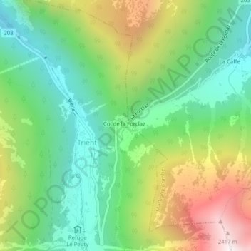
Name: Col de la Forclaz topographic map, elevation, terrain.

Location: Col de la Forclaz, Trient, Martigny, Wallis, 1929, Switzerland (46.05767 7.00130 46.05777 7.00140)

Average elevation: 1,637 m

Minimum elevation: 1,186 m

Maximum elevation: 2,433 m

Gear up for your next adventure:

🧤Insulated Winter Gloves - Heavy-duty protection for sub-zero Canadian adventures
🏕️Camping Hammock - Integrated protection for sleeping between trees
🔦LED Flashlight - Powerful and long-lasting flashlight for camping and emergencies
🧥Softshell Jacket - Windproof and breathable jacket for hiking
🧴Insect Repellent - Protect yourself from bugs during outdoor adventures

As an Amazon Associate, this site earns from qualifying purchases at no extra cost to you.