
Lacon topographic map
Click on the map to display elevation.
About this map
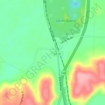
Name: Lacon topographic map, elevation, terrain.
Location: Lacon, Morgan County, Alabama, 35622, United States (34.32482 -86.91334 34.34482 -86.89334)
Average elevation: 201 m
Minimum elevation: 150 m
Maximum elevation: 277 m
Other topographic maps
Click on a map to view its topography, its elevation and its terrain.
Eva
United States > Alabama > Morgan County
According to the U.S. Census Bureau, the town of Eva has a total area of 4.3 square miles (11 km2), of which 0.03 square miles (0.08 km2), or 0.74%, are water. The town center, at an elevation of 1,105 feet (337 m) above sea level, is just north of the Tennessee Valley Divide. The town drains west toward Flint…
Average elevation: 313 m