Geolocate

Somerville topographic map

Click on the map to display elevation.

About this map

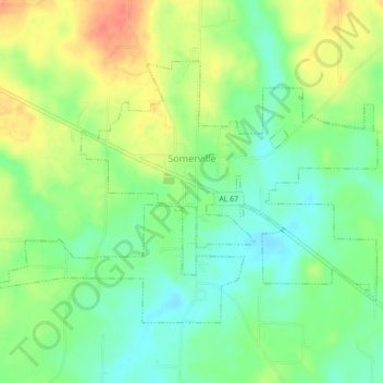
Name: Somerville topographic map, elevation, terrain.

Location: Somerville, Morgan County, Alabama, United States (34.44235 -86.83512 34.49685 -86.75208)

Average elevation: 204 m

Minimum elevation: 172 m

Maximum elevation: 245 m

Other topographic maps

Click on a map to view its topography, its elevation and its terrain.

Brooksville

United States > Alabama > Morgan County > Priceville

Average elevation: 238 m

Union Hill

United States > Alabama > Morgan County

Average elevation: 305 m

Albany

United States > Alabama > Morgan County > Decatur

Average elevation: 174 m

Lacon

United States > Alabama > Morgan County

Average elevation: 201 m

Stanton Hill

United States > Alabama > Morgan County

Average elevation: 223 m

Cedar Lake

United States > Alabama > Morgan County > Decatur

Average elevation: 177 m

Albany

United States > Alabama > Morgan County > Decatur

Average elevation: 174 m

Decatur

United States > Alabama > Morgan County > Decatur > Decatur

Average elevation: 190 m

Gear up for your next adventure:

💧Collapsible Water Bottle - Space-saving water bottle for outdoor activities
💧Hydration Bladder - Hands-free hydration solution for long treks
🥾Trekking Boots - Durable boots for long-distance trekking
🪑Insulated Seat Pad - Protect your seat from cold rocks and wet logs
🧥Waterproof Jacket - Lightweight rain jackets for hiking and outdoor activities

As an Amazon Associate, this site earns from qualifying purchases at no extra cost to you.