Geolocate

Priceville topographic map

Click on the map to display elevation.

About this map

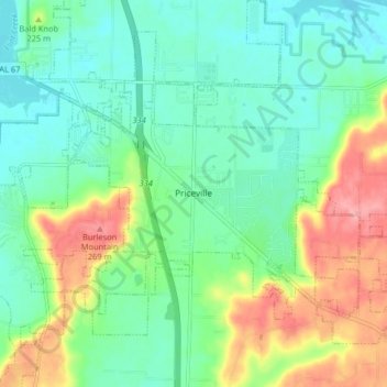
Name: Priceville topographic map, elevation, terrain.

Location: Priceville, Morgan County, Alabama, United States (34.49152 -86.92018 34.55833 -86.84266)

Average elevation: 201 m

Minimum elevation: 166 m

Maximum elevation: 273 m

Other topographic maps

Click on a map to view its topography, its elevation and its terrain.

Brooksville

United States > Alabama > Morgan County > Priceville

Average elevation: 238 m

Lacon

United States > Alabama > Morgan County

Average elevation: 201 m

Albany

United States > Alabama > Morgan County > Decatur

Average elevation: 174 m

Cedar Lake

United States > Alabama > Morgan County > Decatur

Average elevation: 177 m

Albany

United States > Alabama > Morgan County > Decatur

Average elevation: 174 m

Stanton Hill

United States > Alabama > Morgan County

Average elevation: 223 m

Decatur

United States > Alabama > Morgan County > Decatur > Decatur

Average elevation: 190 m

Gear up for your next adventure:

🥾Hiking Shorts - Breathable shorts suitable for summer hikes
🧭GPS Tracker - Track your location in remote areas safely
🧥Packable Rain Jacket - Breathable waterproof layer for unpredictable weather
🥾Lightweight Hiking Boots - Boots for comfort and mobility on long hikes
🪑Ultralight Camping Stool - Compact seating for rest stops during long hikes

As an Amazon Associate, this site earns from qualifying purchases at no extra cost to you.