Geolocate

Decatur topographic map

Click on the map to display elevation.

About this map

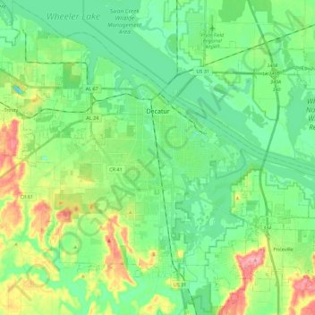
Name: Decatur topographic map, elevation, terrain.

Location: Decatur, Morgan County, Alabama, United States (34.48630 -87.10551 34.67087 -86.89729)

Average elevation: 184 m

Minimum elevation: 149 m

Maximum elevation: 266 m

Other topographic maps

Click on a map to view its topography, its elevation and its terrain.

Union Hill

United States > Alabama > Morgan County

Average elevation: 305 m

Brooksville

United States > Alabama > Morgan County > Priceville

Average elevation: 238 m

Albany

United States > Alabama > Morgan County > Decatur

Average elevation: 174 m

Lacon

United States > Alabama > Morgan County

Average elevation: 201 m

Stanton Hill

United States > Alabama > Morgan County

Average elevation: 223 m

Cedar Lake

United States > Alabama > Morgan County > Decatur

Average elevation: 177 m

Albany

United States > Alabama > Morgan County > Decatur

Average elevation: 174 m

Decatur

United States > Alabama > Morgan County > Decatur > Decatur

Average elevation: 190 m

Gear up for your next adventure:

🥾Lightweight Hiking Boots - Boots for comfort and mobility on long hikes
🚑Survival Whistle - Signal for help across long distances in mountains
🧢Beanie Hat - Keep your head warm in cold weather
🧊Insulated Water Bottle - Keeps drinks cold in summer and prevents freezing in winter
🧤Rechargeable Heated Gloves - Extreme warmth for Canadian winter expeditions

As an Amazon Associate, this site earns from qualifying purchases at no extra cost to you.