Geolocate

Mocupe topographic map

Click on the map to display elevation.

About this map

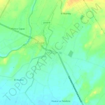
Name: Mocupe topographic map, elevation, terrain.

Location: Mocupe, Lagunas, Province of Chiclayo, Lambayeque, Peru (-7.01116 -79.64225 -6.97116 -79.60225)

Average elevation: 35 m

Minimum elevation: 25 m

Maximum elevation: 51 m

Other topographic maps

Click on a map to view its topography, its elevation and its terrain.

Monsefú

Peru > Lambayeque

Average elevation: 13 m

Motupe

Peru > Lambayeque

Average elevation: 305 m

Mórrope

Peru > Lambayeque

Average elevation: 20 m

Chiclayo

Peru > Lambayeque

Average elevation: 28 m

Monsefú

Peru > Lambayeque

Average elevation: 13 m

Lambayeque

Peru > Lambayeque > Lambayeque

Average elevation: 24 m

Pátapo

Peru > Lambayeque

Average elevation: 180 m

Gear up for your next adventure:

💡Compact LED Flashlight - Powerful and portable flashlight for outdoor use
🧥Insulated Jacket - Keep warm in cold outdoor conditions
🔦LED Headlamp - Hands-free lighting for early morning starts or late finishes
🛶Kayak Accessories - Essential gear for safe and fun kayaking adventures
🧢Hiking Sun Hat - Wide-brimmed protection for exposed mountain ridges

As an Amazon Associate, this site earns from qualifying purchases at no extra cost to you.