Geolocate

Motupe topographic map

Click on the map to display elevation.

About this map

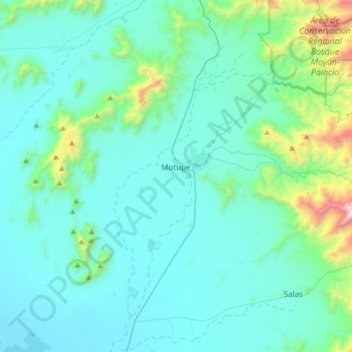
Name: Motupe topographic map, elevation, terrain.

Location: Motupe, Province of Lambayeque, Lambayeque, Peru (-6.32845 -79.83040 -5.99726 -79.55215)

Average elevation: 305 m

Minimum elevation: 59 m

Maximum elevation: 1,997 m

Other topographic maps

Click on a map to view its topography, its elevation and its terrain.

Los Jagueyes de Mayascón

Peru > Lambayeque > Pítipo

Average elevation: 555 m

Mayascón

Peru > Lambayeque

Average elevation: 402 m

C

Peru > Lambayeque > Chiclayo

Average elevation: 24 m

Mocupe

Peru > Lambayeque

Average elevation: 35 m

Morrope

Peru > Lambayeque > Mórrope

Average elevation: 19 m

Chiclayo

Peru > Lambayeque > Chiclayo

Average elevation: 39 m

Puerto Etén

Peru > Lambayeque > Etén Puerto > Puerto Etén

Average elevation: 11 m

Gear up for your next adventure:

🧰Emergency Multi-Tool - Compact multi-tool for outdoor survival
🔥Emergency Fire Starter - Reliable ignition source for all weather conditions
🗺️Topographic Maps - Detailed maps to explore trails, mountains, and wilderness areas
🚲Heavy Duty Bike Lock - Secure your bike at the trailhead or during stops
🧰Survival Kit - Essential gear for emergencies in the wilderness

As an Amazon Associate, this site earns from qualifying purchases at no extra cost to you.