Geolocate

Lambayeque topographic map

Click on the map to display elevation.

About this map

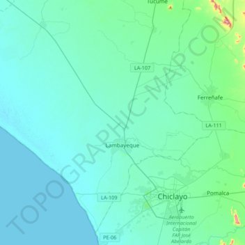
Name: Lambayeque topographic map, elevation, terrain.

Location: Lambayeque, Province of Lambayeque, Lambayeque, Peru (-6.75543 -80.11175 -6.58963 -79.78143)

Average elevation: 24 m

Minimum elevation: 0 m

Maximum elevation: 241 m

Gear up for your next adventure:

Lightweight Backpacking Tent - Compact tent for efficient hiking trips
🧥Thermal Layer - Insulating layer for cold outdoor conditions
🛶Waterproof Dry Bags - Keep electronics and clothes dry during river crossings
🧢Outdoor Visor - Breathable visor for sunny hikes
💧Hydration Pack - Hands-free hydration system for long hikes

As an Amazon Associate, this site earns from qualifying purchases at no extra cost to you.