
Maharashtra topographic map
Click on the map to display elevation.
Maharashtra
Maharashtra with a total area of 307,713 km2 (118,809 sq mi), is the third-largest state by area in terms of land area and constitutes 9.36% of India's total geographical area. The State lies between 15°35' N to 22°02' N latitude and 72°36' E to 80°54' E longitude. It occupies the western and central part of the country and has a coastline stretching 840 kilometres (520 mi) along the Arabian Sea. The dominant physical feature of the state is its plateau character, which is separated from the Konkan coastline by the mountain range of the Western Ghats, which runs parallel to the coast from north to south. The Western Ghats, also known as the Sahyadri Range, has an average elevation of 1,200 metres (3,900 ft); its slopes gently descending towards the east and southeast. The Western Ghats (or the Sahyadri Mountain range) provide a physical barrier to the state on the west, while the Satpura Hills along the north and Bhamragad-Chiroli-Gaikhuri ranges on the east serve as its natural borders. This state's expansion from North to South is 720 km (450 mi) and East to West is 800 km (500 mi). To the west of these hills lie the Konkan coastal plains, 50–80 km (31–50 mi) in width. To the east of the Ghats lies the flat Deccan Plateau. The main rivers of the state are the Krishna, and its tributary, Bhima, the Godavari, and its main tributaries, Manjara, and Wardha-Wainganga and the Tapi, and its tributary Purna. Maharashtra is divided into five geographic regions. Konkan is the western coastal region, between the Western Ghats and the sea. Khandesh is the north region lying in the valley of the Tapti, Purna river. Nashik, Malegaon Jalgaon, Dhule and Bhusawal are the major cities of this region. Desh is in the centre of the state. Marathwada, which was a part of the princely state of Hyderabad until 1956, is located in the southeastern part of the state. Aurangabad and Nanded are the main cities of the region. Vidarbha is the easternmost region of the state, formerly part of the Central Provinces and Berar.
About this map
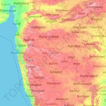
Name: Maharashtra topographic map, elevation, terrain.
Location: Maharashtra, India (15.60636 72.65261 22.03027 80.89778)
Average elevation: 364 m
Minimum elevation: -1 m
Maximum elevation: 1,409 m
Other topographic maps
Click on a map to view its topography, its elevation and its terrain.
Maharashtra
Maharashtra is the third largest state by area in India. The Western Ghats better known as Sahyadri, are a hilly range running parallel to the coast, at an average elevation of 1,200 metres (4,000 ft). Kalsubai, a peak in the Sahyadris, near Nashik city is the highest elevated point in Maharashtra. To the west…
Average elevation: 478 m
Guwahati
Professor Abani Kumar Bhagawati of Gauhati University stated that since before there were sufficient wetlands to absorb rainwater and channels to carry excess water to the Brahmaputra, the city did not experience floods. However, human interference has disrupted the natural topography, leading to the current…
Average elevation: 113 m
Thiruvananthapuram
India > Kerala > Thiruvananthapuram
Thiruvananthapuram is built on seven hills by the seashore and is at 8°30′N 76°54′E / 8.5°N 76.9°E / 8.5; 76.9 on the west coast, near the southern tip of mainland India. The city is on the west coast of India and is bounded by the Laccadive Sea to its west and the Western Ghats to its east.…
Average elevation: 33 m
Dehradun
India > Uttarakhand > Dehradun
The city of Dehradun mainly lies in Doon Valley and is at a varying height from 410 m (1,350 ft) in Clement Town to above 700 m (2,300 ft) at Malsi which is 15 km (9.3 mi) from the city. However, the average elevation is 450 m (1,480 ft) above sea level. Malsi is the starting point of Lesser Himalayan Range…
Average elevation: 904 m
Chennai
Chennai is located on the south–eastern coast of India in the north–eastern part of Tamil Nadu on a flat coastal plain known as the Eastern Coastal Plains. Its average elevation is around 6.7 metres (22 ft), and its highest point is 60 m (200 ft). Chennai is 2,184 kilometres (1,357 mi) south of Delhi,…
Average elevation: 7 m
Mumbai
Mumbai lies at the mouth of the Ulhas River on the western coast of India, in the coastal region known as the Konkan. It sits on Salsette Island (Sashti Island), which it partially shares with the Thane district. Mumbai is bounded by the Arabian Sea to the west. Many parts of the city lie just above sea level,…
Average elevation: 13 m
Kunigal
India > Karnataka > Kunigal taluk
Kunigal is located at 13°01′N 77°02′E / 13.02°N 77.03°E / 13.02; 77.03. It has an average elevation of 773 metres (2536 feet). It is situated on the National Highway 75 (India) connecting Bengaluru and Mangaluru and State Highway 33 (Karnataka) connecting Tumakuru and Madduru. Kunigal is…
Average elevation: 775 m
Digha
India > West Bengal > Digha
Digha is located at 21°38′18″N 87°30′35″E / 21.6384°N 87.5096°E / 21.6384; 87.5096. It has an average elevation of 6 metres (20 ft).
Average elevation: 4 m
Salem
Salem is located at 11°40′N 78°08′E / 11.67°N 78.14°E / 11.67; 78.14, at an average elevation of 278 m (912 ft). The city is surrounded by hills: Nagaramalai on the north, Jarugumalai on the south, Kanjamalai on the west, Godumalai on the east and the Shevaroy Hills on the northeast.…
Average elevation: 418 m
Mangalagiri
India > Andhra Pradesh > Mangalagiri
Mangalagiri is located at 16°26′N 80°33′E / 16.43°N 80.55°E / 16.43; 80.55. It has an average elevation of 29.08 m (95.4 ft).It is located 22 kilometres (14 mi) north east of the district headquarters, Guntur, and just 15 km (9.3 mi) south west of Vijayawada and also 30 km (19 mi) to the north…
Average elevation: 29 m
Dombivli
India > Maharashtra > Kalyan Subdistrict > Kalyan-Dombivli
Dombivli is located at 19°13′06″N 73°05′12″E / 19.218433°N 73.086718°E / 19.218433; 73.086718. It has an average elevation of 13.534 meters (44.403 feet). The land here is rough and rocky by nature. The Ulhas river flows from its north.
Average elevation: 11 m
Kannur
India > Kerala > Kannur > Kannur
Kannur has an elevation of 1.02 metres or 3.3 feet along the coast of the Laccadive Sea, with a sandy coastal area. The city has an 8 kilometres (5.0 mi)-long seashore and a 3 kilometres (1.9 mi)-long beach at Payyambalam. Kannur is located north of Kozhikode, south of Kasargod and Mangalore, west of the…
Average elevation: 13 m
Shimla
Shimla is on the south-western ranges of the Himalayas at 31°37′N 77°06′E / 31.61°N 77.10°E / 31.61; 77.10. It has an average altitude of 2,206 metres (7,238 ft) above mean sea level and extends along a ridge with seven spurs. The city stretches nearly 9.2 kilometres (5.7 mi) from east to west.
Average elevation: 1,557 m
Kothagudem
India > Telangana > Kothagudem mandal
Kothagudem is located at 17°33′00″N 80°37′05″E / 17.55°N 80.618°E / 17.55; 80.618. It has an average elevation of 89 metres (295 ft) above sea level. The North of Kothagudem borders Chhattisgarh state which is approximately 120 km from the town.
Average elevation: 109 m
Vadodara
India > Gujarat > Vadodara Rural Taluka
Vadodara is located at 22°18′N 73°11′E / 22.30°N 73.19°E / 22.30; 73.19 in western India at an elevation of 39 metres (128 ft). It is the tenth-largest city in India with an area of 400 square kilometres (150 sq mi) and a population of 3.5 million, according to the 2010–11 census. The city…
Average elevation: 36 m
Chandigarh
India > Chandigarh > Chandigarh
Chandigarh is located by the foothills of the Shivalik Range of the Himalayas in northwest India. It covers an area of approximately 114 km2. It borders the states of Punjab and Haryana. The exact geographic coordinates of Chandigarh are 30°44′N 76°47′E / 30.74°N 76.79°E / 30.74; 76.79. It has…
Average elevation: 378 m
Ayodhya
India > Uttar Pradesh > Faizabad
The earliest of the Buddhist Pali-language texts and the Jain Prakrit-language texts mention a city called Saketa (Sageya or Saeya in Prakrit) as an important city of the Kosala mahajanapada. Topographical indications in both Buddhist and Jain texts suggest that Saketa is the same as the present-day Ayodhya.…
Average elevation: 96 m
Jasdan
India > Gujarat > Jasdan Taluka
Jasdan is located at 22°02′N 71°12′E / 22.03°N 71.2°E / 22.03; 71.2. It has an average elevation of 293 metres (1633 feet). Jasdan is the biggest Taluka place in Rajkot district and has 103 villages. Geographically it is the heart of the Mandava Hills from where most of the rivers of…
Average elevation: 198 m
Machilipatnam
India > Andhra Pradesh > Machilipatnam
Salabat Jung, the son of Nizam-ul-Mulk Asaf Jah I, who was indebted for his elevation to the throne to the French East India Company, granted them in return for their services the district of Kondavid or Guntur, and soon afterwards the remainder of the Circars. The Circars were captured by the British from the…
Average elevation: 4 m
Gangtok
India > Sikkim > Gangtok subdivision
Gangtok (Nepali: gāntok, pronounced [gantok], Sikkimese: [ɡaŋt̪ʰòk]) is the capital and the most populous city of the Indian state of Sikkim. The seat of eponymous district, Gangtok is in the eastern Himalayan range, at an elevation of 1,650 m (5,410 ft). The city's population of 100,000 consists of the…
Average elevation: 1,911 m
Jabalpur
India > Madhya Pradesh > Jabalpur Tahsil > Jabalpur
The Narmada river bringing in freshwater from the Vindyachal Ranges has developed Jabalpur district into an agrarian economy. The land of the Narmada basin with its fertile alluvial soil gives good yields of sorghum, wheat, rice, and millet in the villages around Jabalpur. Important among commercial crops are…
Average elevation: 413 m