Geolocate

Valpoi topographic map

Click on the map to display elevation.

About this map

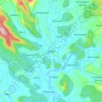
Name: Valpoi topographic map, elevation, terrain.

Location: Valpoi, Satari, North Goa, Goa, 403506, India (15.49147 74.09728 15.57147 74.17728)

Average elevation: 73 m

Minimum elevation: 9 m

Maximum elevation: 385 m

Other topographic maps

Click on a map to view its topography, its elevation and its terrain.

Mhadei Wildlife Sanctuary

India > Goa > Satari

Average elevation: 364 m

Surla

India > Goa > Satari > Nanorem

Average elevation: 384 m

Mhadei Wildlife Sanctuary

India > Goa > Satari > Caranzol

Average elevation: 415 m

Gear up for your next adventure:

🧤Insulated Winter Gloves - Heavy-duty protection for sub-zero Canadian adventures
🧼Biodegradable Camp Soap - Environmentally friendly cleaning for gear and body
🧥Ultralight Puffy Jacket - Maximum warmth that packs down to the size of an orange
🛌Insulated Sleeping Pad - Critical thermal barrier between you and the cold ground
🥾Waterproof Hiking Boots - Essential footwear for rugged terrain and wet Canadian trails

As an Amazon Associate, this site earns from qualifying purchases at no extra cost to you.