Geolocate

Barr Lake topographic map

Click on the map to display elevation.

About this map

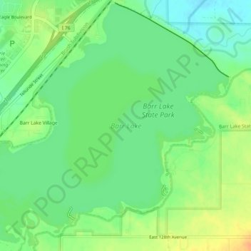
Name: Barr Lake topographic map, elevation, terrain.

Location: Barr Lake, Adams County, Colorado, United States (39.92730 -104.78595 39.96067 -104.74134)

Average elevation: 1,555 m

Minimum elevation: 1,539 m

Maximum elevation: 1,575 m

Other topographic maps

Click on a map to view its topography, its elevation and its terrain.

Bennett

United States > Colorado > Adams County

Average elevation: 1,692 m

Western Hills

United States > Colorado > Adams County

Average elevation: 1,604 m

Aurora

United States > Colorado > Adams County > Aurora

Average elevation: 1,660 m

Brighton

United States > Colorado > Adams County

Average elevation: 1,533 m

Sherrelwood

United States > Colorado > Adams County > Western Hills

Average elevation: 1,621 m

Welby

United States > Colorado > Adams County > Welby

Average elevation: 1,575 m

Bennett

United States > Colorado > Adams County > Bennett

Average elevation: 1,677 m

Federal Heights

United States > Colorado > Adams County

Average elevation: 1,665 m

Gear up for your next adventure:

🔨Vehicle Emergency Tool - Safety tool for remote road trips to trailheads
🧥Waterproof Pants - Keep dry during rainy hiking conditions
🧥Waterproof Hiking Jacket - Protect yourself from rain and wind while hiking
Family Camping Tent - Spacious tent suitable for family camping trips
🧊Portable Cooler - Keep food and drinks cold during outdoor adventures

As an Amazon Associate, this site earns from qualifying purchases at no extra cost to you.