Geolocate

Bennett topographic map

Click on the map to display elevation.

About this map

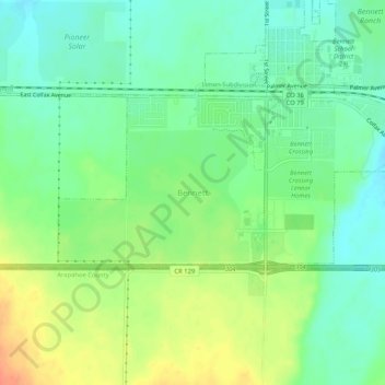
Name: Bennett topographic map, elevation, terrain.

Location: Bennett, Adams County, Colorado, 80102, United States (39.72602 -104.46320 39.76602 -104.42320)

Average elevation: 1,677 m

Minimum elevation: 1,659 m

Maximum elevation: 1,705 m

Gear up for your next adventure:

🥾Waterproof Hiking Boots - Boots keeping your feet dry in wet conditions
🥾Light Hiking Boots - Lightweight and comfortable boots for day hikes
🥾Hiking Gaiters - Protect legs and shoes from mud, snow, and debris
🔦LED Headtorch - Bright and durable light for night activities
🚲Bike Repair Kit - Essential tools for on-trail mechanical issues

As an Amazon Associate, this site earns from qualifying purchases at no extra cost to you.