Geolocate

Bennett topographic map

Click on the map to display elevation.

About this map

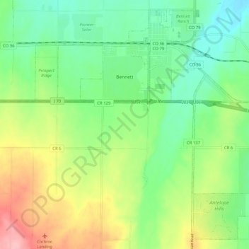
Name: Bennett topographic map, elevation, terrain.

Location: Bennett, Adams County, Colorado, 80102, United States (39.69468 -104.48012 39.76717 -104.37794)

Average elevation: 1,692 m

Minimum elevation: 1,642 m

Maximum elevation: 1,778 m

Other topographic maps

Click on a map to view its topography, its elevation and its terrain.

Western Hills

United States > Colorado > Adams County

Average elevation: 1,604 m

Aurora

United States > Colorado > Adams County > Aurora

Average elevation: 1,660 m

Brighton

United States > Colorado > Adams County

Average elevation: 1,533 m

Barr Lake

United States > Colorado > Adams County

Average elevation: 1,555 m

Todd Creek

United States > Colorado > Adams County

Average elevation: 1,568 m

Sherrelwood

United States > Colorado > Adams County > Western Hills

Average elevation: 1,621 m

Berkley

United States > Colorado > Adams County > Berkley

Average elevation: 1,596 m

Sand Creek Park

United States > Colorado > Adams County > Aurora

Average elevation: 1,629 m

Bennett

United States > Colorado > Adams County > Bennett

Average elevation: 1,677 m

Gear up for your next adventure:

🥾Trail Hiking Shoes - Durable shoes designed for rugged trails
💡Compact LED Flashlight - Powerful and portable flashlight for outdoor use
👟Trail Running Shoes - Agile footwear for fast-paced topographic exploration
🧢Outdoor Cap - Protective cap for sun and rain during hikes
🧥Softshell Hiking Jacket - The perfect balance of wind protection and breathability

As an Amazon Associate, this site earns from qualifying purchases at no extra cost to you.