Geolocate

Aurora topographic map

Click on the map to display elevation.

About this map

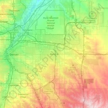
Name: Aurora topographic map, elevation, terrain.

Location: Aurora, Adams County, Colorado, 80045, United States (39.58051 -104.99099 39.90051 -104.67099)

Average elevation: 1,660 m

Minimum elevation: 1,524 m

Maximum elevation: 1,878 m

Other topographic maps

Click on a map to view its topography, its elevation and its terrain.

Sand Creek Park

United States > Colorado > Adams County > Aurora

Average elevation: 1,629 m

Gear up for your next adventure:

🧴Waterproofing Spray - Restore the DWR coating on jackets and tents
🌡️Emergency Mylar Blankets - Compact thermal protection for unexpected nights outdoors
🧭Orienteering Kit - Tools for map reading and navigation in the wild
🦟Insect Repellent - Keep mosquitoes and black flies away in wooded areas
🧰Multitool Knife - Compact and versatile tool for outdoor use

As an Amazon Associate, this site earns from qualifying purchases at no extra cost to you.