Geolocate

Croxall topographic map

Click on the map to display elevation.

About this map

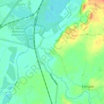
Name: Croxall topographic map, elevation, terrain.

Location: Croxall, Edingale, Lichfield, Staffordshire, England, WS13 8RA, United Kingdom (52.70062 -1.72831 52.74062 -1.68831)

Average elevation: 57 m

Minimum elevation: 45 m

Maximum elevation: 88 m

Other topographic maps

Click on a map to view its topography, its elevation and its terrain.

Hints

United Kingdom > England > Staffordshire > Lichfield

Average elevation: 107 m

Fisherwick

United Kingdom > England > Staffordshire > Lichfield

Average elevation: 63 m

Lichfield

United Kingdom > England > Staffordshire > Lichfield

Average elevation: 91 m

Burntwood

United Kingdom > England > Staffordshire > Lichfield > Chasetown

Average elevation: 147 m

Beacon Park

United Kingdom > England > Staffordshire > Lichfield

Average elevation: 93 m

Longdon

United Kingdom > England > Staffordshire > Lichfield

Average elevation: 114 m

Weeford

United Kingdom > England > Staffordshire > Lichfield

Average elevation: 113 m

Colton

United Kingdom > England > Staffordshire > Lichfield

Average elevation: 90 m

Fazeley

United Kingdom > England > Staffordshire > Lichfield

Average elevation: 78 m

Shenstone

United Kingdom > England > Staffordshire > Lichfield

Average elevation: 125 m

Wall

United Kingdom > England > Staffordshire > Lichfield

Average elevation: 106 m

Alrewas

United Kingdom > England > Staffordshire > Lichfield

Average elevation: 59 m

Gear up for your next adventure:

🧼Travel Hand Sanitizer - Keep hands clean when water is scarce
🧥Softshell Jacket - Windproof and breathable jacket for hiking
🚲MTB Frame Bag - Carry tools and maps directly on your bicycle frame
🧥Fleece Jacket - Warm and lightweight jacket for layering
🛰️Satellite Messenger - Emergency communication for areas with no cell service

As an Amazon Associate, this site earns from qualifying purchases at no extra cost to you.