Geolocate

Harlaston topographic map

Click on the map to display elevation.

About this map

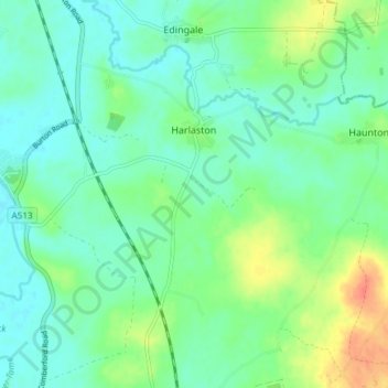
Name: Harlaston topographic map, elevation, terrain.

Location: Harlaston, Lichfield, Staffordshire, England, United Kingdom (52.66561 -1.70589 52.71077 -1.66274)

Average elevation: 65 m

Minimum elevation: 51 m

Maximum elevation: 99 m

Gear up for your next adventure:

🧊Portable Cooler - Keep food and drinks cold during outdoor adventures
🧴Sunscreen SPF - Broad-spectrum sunscreen for outdoor activities
🧭Orienteering Kit - Tools for map reading and navigation in the wild
🔦UV Flashlight - Detect minerals or specific insects in the dark
🦟Insect Repellent - Keep mosquitoes and black flies away in wooded areas

As an Amazon Associate, this site earns from qualifying purchases at no extra cost to you.