Geolocate

Ide Hill topographic map

Click on the map to display elevation.

About this map

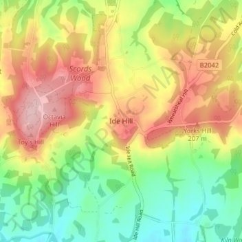
Name: Ide Hill topographic map, elevation, terrain.

Location: Ide Hill, Sevenoaks, Kent, England, TN14 6JT, United Kingdom (51.22685 0.10627 51.26685 0.14627)

Average elevation: 151 m

Minimum elevation: 69 m

Maximum elevation: 244 m

Other topographic maps

Click on a map to view its topography, its elevation and its terrain.

Eynsford

United Kingdom > England > Kent > Sevenoaks > Eynsford

Average elevation: 104 m

Kemsing

United Kingdom > England > Kent > Sevenoaks

Average elevation: 139 m

Darent

United Kingdom > England > Kent > Sevenoaks

Average elevation: 92 m

Sevenoaks

United Kingdom > England > Kent > Sevenoaks

Average elevation: 127 m

Chiddingstone

United Kingdom > England > Kent > Sevenoaks

Average elevation: 64 m

Riverhead

United Kingdom > England > Kent > Sevenoaks

Average elevation: 131 m

Shoreham

United Kingdom > England > Kent > Sevenoaks

Average elevation: 123 m

Hartley

United Kingdom > England > Kent > Sevenoaks

Average elevation: 99 m

Fawkham

United Kingdom > England > Kent > Sevenoaks

Average elevation: 108 m

Cowden

United Kingdom > England > Kent > Sevenoaks

Average elevation: 90 m

Crockenhill

United Kingdom > England > Kent > Sevenoaks

Average elevation: 96 m

Seal

United Kingdom > England > Kent > Sevenoaks

Average elevation: 117 m

Penshurst

United Kingdom > England > Kent > Sevenoaks

Average elevation: 66 m

Westerham

United Kingdom > England > Kent > Sevenoaks > Hosey Hill

Average elevation: 134 m

Hextable

United Kingdom > England > Kent > Sevenoaks > Hextable

Average elevation: 61 m

Shoreham

United Kingdom > England > Kent > Sevenoaks

Average elevation: 123 m

Riverhead

United Kingdom > England > Kent > Sevenoaks

Average elevation: 131 m

Hever

United Kingdom > England > Kent > Sevenoaks

Average elevation: 65 m

Eynsford

United Kingdom > England > Kent > Sevenoaks > Eynsford

Average elevation: 104 m

Seal

United Kingdom > England > Kent > Sevenoaks

Average elevation: 117 m

Sevenoaks

United Kingdom > England > Kent > Sevenoaks

Average elevation: 127 m

Penshurst

United Kingdom > England > Kent > Sevenoaks

Average elevation: 66 m

Gear up for your next adventure:

🛰️Satellite Messenger - Emergency communication for areas with no cell service
🧥Thermal Fleece Jacket - Versatile insulation for changing mountain temperatures
🥾Waterproof Hiking Boots - Essential footwear for rugged terrain and wet Canadian trails
🦶Hiking Shoe Insoles - Added support for high arches and long days on feet
🧼Travel Hand Sanitizer - Keep hands clean when water is scarce

As an Amazon Associate, this site earns from qualifying purchases at no extra cost to you.