Geolocate

Knockholt topographic map

Click on the map to display elevation.

About this map

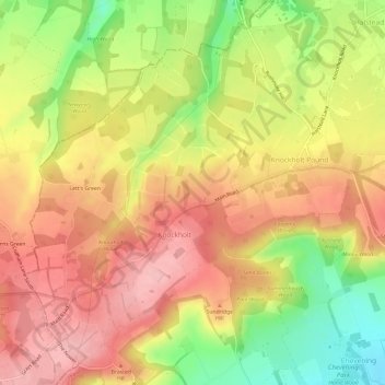
Name: Knockholt topographic map, elevation, terrain.

Location: Knockholt, Sevenoaks, Kent, England, United Kingdom (51.29683 0.08279 51.33029 0.14263)

Average elevation: 180 m

Minimum elevation: 90 m

Maximum elevation: 244 m

Other topographic maps

Click on a map to view its topography, its elevation and its terrain.

Ash

United Kingdom > England > Kent > Sevenoaks

Average elevation: 139 m

Seal Chart

United Kingdom > England > Kent > Sevenoaks > Styants Bottom

Average elevation: 143 m

Knockholt Pound

United Kingdom > England > Kent > Sevenoaks

Average elevation: 169 m

Godden Green

United Kingdom > England > Kent > Sevenoaks

Average elevation: 144 m

Halstead

United Kingdom > England > Kent > Sevenoaks

Average elevation: 156 m

Horton Kirby

United Kingdom > England > Kent > Sevenoaks

Average elevation: 63 m

South Darenth

United Kingdom > England > Kent > Sevenoaks

Average elevation: 50 m

Heaverham

United Kingdom > England > Kent > Sevenoaks

Average elevation: 142 m

Knatts Valley

United Kingdom > England > Kent > Sevenoaks > East Hill > Knockmill

Average elevation: 170 m

Lett's Green

United Kingdom > England > Kent > Sevenoaks > Knockholt

Average elevation: 183 m

Hosey Hill

United Kingdom > England > Kent > Sevenoaks

Average elevation: 151 m

Badger's Mount

United Kingdom > England > Kent > Sevenoaks

Average elevation: 138 m

Sundridge

United Kingdom > England > Kent > Sevenoaks

Average elevation: 116 m

Horseshoe Green

United Kingdom > England > Kent > Sevenoaks > Markbeech

Average elevation: 86 m

Toy's Hill

United Kingdom > England > Kent > Sevenoaks

Average elevation: 159 m

Betsom's Hill

United Kingdom > England > Kent > Sevenoaks

Average elevation: 190 m

Chiddingstone Hoath

United Kingdom > England > Kent > Sevenoaks

Average elevation: 75 m

Ide Hill

United Kingdom > England > Kent > Sevenoaks

Average elevation: 151 m

Chevening

United Kingdom > England > Kent > Sevenoaks

Average elevation: 126 m

Bore Place

United Kingdom > England > Kent > Sevenoaks > Chiddingstone

Average elevation: 76 m

New Ash Green

United Kingdom > England > Kent > Sevenoaks

Average elevation: 123 m

Weardale

United Kingdom > England > Kent > Sevenoaks > French Street

Average elevation: 171 m

Crockham Hill

United Kingdom > England > Kent > Sevenoaks

Average elevation: 118 m

Hill Hoath

United Kingdom > England > Kent > Sevenoaks > Hill Hoath

Average elevation: 59 m

Four Elms

United Kingdom > England > Kent > Sevenoaks

Average elevation: 67 m

Fawkham Green

United Kingdom > England > Kent > Sevenoaks

Average elevation: 125 m

Sundridge

United Kingdom > England > Kent > Sevenoaks

Average elevation: 116 m

Ridley

United Kingdom > England > Kent > Sevenoaks > Hodsoll Street

Average elevation: 146 m

New Ash Green

United Kingdom > England > Kent > Sevenoaks

Average elevation: 123 m

Gear up for your next adventure:

🥾Approach Shoes - Shoes designed for climbing approaches and rugged trails
🗺️Topographic Maps - Detailed maps to explore trails, mountains, and wilderness areas
🧥Thermal Fleece Jacket - Versatile insulation for changing mountain temperatures
🩹Moleskin Blister Pads - Direct protection for painful foot pressure points
🧴First Aid Kit - Essential first aid supplies for outdoor emergencies

As an Amazon Associate, this site earns from qualifying purchases at no extra cost to you.