
Smithville topographic map
Interactive map
Click on the map to display elevation.
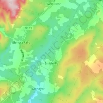
Smithville topographic map, elevation, terrain
About this map
Name: Smithville topographic map, elevation, terrain.
Average elevation: 121 m
Minimum elevation: 11 m
Maximum elevation: 321 m
Routes: Municipality of the County of Inverness GPS tracks, routes, trails, hikes
Other topographic maps
Click on a map to view its topography, its elevation and its terrain.
Meat Cove
Canada > Nova Scotia > Municipality of the County of Inverness > Meat Cove
Average elevation: 117 m
Margaree Forks
Canada > Nova Scotia > Municipality of the County of Inverness
Average elevation: 134 m
Upper Glencoe
Canada > Nova Scotia > Municipality of the County of Inverness > Glencoe
Average elevation: 181 m
West Lake Ainslie
Canada > Nova Scotia > Municipality of the County of Inverness
Average elevation: 119 m
Margaree Harbour
Canada > Nova Scotia > Municipality of the County of Inverness
Average elevation: 108 m
Cape Breton Highlands National Park
Canada > Nova Scotia > Municipality of the County of Inverness
Average elevation: 330 m
Polletts Cove - Aspy Fault Wilderness Area
Canada > Nova Scotia > Municipality of the County of Inverness > Meat Cove > Capstick
Average elevation: 193 m
Big Harbour Island
Canada > Nova Scotia > Municipality of the County of Inverness
Average elevation: 3 m
Long Point Provincial Park
Canada > Nova Scotia > Municipality of the County of Inverness > Long Point
Average elevation: 32 m
South Side River Denys
Canada > Nova Scotia > Municipality of the County of Inverness
Average elevation: 89 m
West Mabou Beach Provincial Park
Canada > Nova Scotia > Municipality of the County of Inverness > West Mabou
Average elevation: 21 m
Hawleys Hill
Canada > Nova Scotia > Municipality of the County of Inverness > Mabou
Average elevation: 90 m
Churchview
Canada > Nova Scotia > Municipality of the County of Inverness > Churchview
Average elevation: 127 m
Margaree Centre
Canada > Nova Scotia > Municipality of the County of Inverness
Average elevation: 94 m