
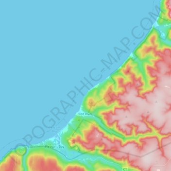
Red River topographic map
Interactive map
Click on the map to display elevation.
About this map
Name: Red River topographic map, elevation, terrain.
Average elevation: 117 m
Minimum elevation: 0 m
Maximum elevation: 465 m
Other topographic maps
Click on a map to view its topography, its elevation and its terrain.
West Lake Ainslie
Canada > Nova Scotia > Municipality of the County of Inverness
West Lake Ainslie, Municipality of the County of Inverness, Inverness County, Nova Scotia, Canada
Average elevation: 119 m
Point Cross
Canada > Nova Scotia > Municipality of the County of Inverness
Point Cross, Municipality of the County of Inverness, Inverness County, Nova Scotia, Canada
Average elevation: 97 m
Margaree Harbour
Canada > Nova Scotia > Municipality of the County of Inverness
Margaree Harbour, Municipality of the County of Inverness, Inverness County, Nova Scotia, Canada
Average elevation: 108 m
La Prairie
Canada > Nova Scotia > Municipality of the County of Inverness
La Prairie, Municipality of the County of Inverness, Inverness County, Nova Scotia, Canada
Average elevation: 172 m
Broad Cove
Canada > Nova Scotia > Municipality of the County of Inverness
Broad Cove, Municipality of the County of Inverness, Inverness County, Nova Scotia, Canada
Average elevation: 130 m
Polletts Cove - Aspy Fault Wilderness Area
Canada > Nova Scotia > Municipality of the County of Inverness > Meat Cove > Capstick
Polletts Cove - Aspy Fault Wilderness Area, Capstick, Meat Cove, Municipality of the County of Inverness, Inverness County, Nova Scotia, Canada
Average elevation: 193 m
Sugar Camp
Canada > Nova Scotia > Municipality of the County of Inverness
Sugar Camp, Municipality of the County of Inverness, Inverness County, Nova Scotia, Canada
Average elevation: 68 m
Cape Breton Highlands National Park
Canada > Nova Scotia > Municipality of the County of Inverness
Cape Breton Highlands National Park, Municipality of the County of Inverness, Inverness County, Nova Scotia, Canada
Average elevation: 330 m
Big Harbour Island
Canada > Nova Scotia > Municipality of the County of Inverness
Big Harbour Island, Municipality of the County of Inverness, Inverness County, Nova Scotia, Canada
Average elevation: 3 m
Troy
Canada > Nova Scotia > Municipality of the County of Inverness
Troy, Municipality of the County of Inverness, Inverness County, Nova Scotia, Canada
Average elevation: 81 m
Askilton
Canada > Nova Scotia > Municipality of the County of Inverness
Askilton, Municipality of the County of Inverness, Inverness County, Nova Scotia, Canada
Average elevation: 39 m
Creignish
Canada > Nova Scotia > Municipality of the County of Inverness
Creignish, Municipality of the County of Inverness, Inverness County, Nova Scotia, B9A 1B4, Canada
Average elevation: 101 m
Long Point Provincial Park
Canada > Nova Scotia > Municipality of the County of Inverness > Long Point
Long Point Provincial Park, Long Point, Municipality of the County of Inverness, Inverness County, Nova Scotia, Canada
Average elevation: 32 m
Stoney Point
Canada > Nova Scotia > Municipality of the County of Inverness
Stoney Point, Municipality of the County of Inverness, Inverness County, Nova Scotia, Canada
Average elevation: 10 m
South Side River Denys
Canada > Nova Scotia > Municipality of the County of Inverness
South Side River Denys, Municipality of the County of Inverness, Inverness County, Nova Scotia, B0E 2Y0, Canada
Average elevation: 89 m
River Denys
Canada > Nova Scotia > Municipality of the County of Inverness
River Denys, Municipality of the County of Inverness, Inverness County, Nova Scotia, Canada
Average elevation: 29 m
Dunmore
Canada > Nova Scotia > Municipality of the County of Inverness
Dunmore, Municipality of the County of Inverness, Inverness County, Nova Scotia, Canada
Average elevation: 28 m
Whycocomagh
Canada > Nova Scotia > Municipality of the County of Inverness
Whycocomagh, Municipality of the County of Inverness, Inverness County, Nova Scotia, B0E 3M0, Canada
Average elevation: 135 m
West Mabou Beach Provincial Park
Canada > Nova Scotia > Municipality of the County of Inverness > West Mabou
West Mabou Beach Provincial Park, West Mabou, Municipality of the County of Inverness, Inverness County, Nova Scotia, Canada
Average elevation: 21 m
Kewstoke
Canada > Nova Scotia > Municipality of the County of Inverness
Kewstoke, Municipality of the County of Inverness, Inverness County, Nova Scotia, Canada
Average elevation: 161 m
Cheticamp
Canada > Nova Scotia > Municipality of the County of Inverness
Cheticamp, Municipality of the County of Inverness, Inverness County, Nova Scotia, B0E 1H0, Canada
Average elevation: 14 m
Keppoch
Canada > Nova Scotia > Municipality of the County of Inverness
Keppoch, Municipality of the County of Inverness, Inverness County, Nova Scotia, Canada
Average elevation: 227 m
Mabou Harbour
Canada > Nova Scotia > Municipality of the County of Inverness
Mabou Harbour, Municipality of the County of Inverness, Inverness County, Nova Scotia, Canada
Average elevation: 105 m
Mabou
Canada > Nova Scotia > Municipality of the County of Inverness
Mabou, Municipality of the County of Inverness, Inverness County, Nova Scotia, Canada
Average elevation: 81 m
Colindale
Canada > Nova Scotia > Municipality of the County of Inverness
Colindale, Municipality of the County of Inverness, Inverness County, Nova Scotia, Canada
Average elevation: 54 m
Hawleys Hill
Canada > Nova Scotia > Municipality of the County of Inverness > Mabou
Hawleys Hill, Mabou, Municipality of the County of Inverness, Inverness County, Nova Scotia, B0E 1X0, Canada
Average elevation: 90 m
Port Hood
Canada > Nova Scotia > Municipality of the County of Inverness
Port Hood, Municipality of the County of Inverness, Inverness County, Nova Scotia, B0E 2W0, Canada
Average elevation: 35 m
Churchview
Canada > Nova Scotia > Municipality of the County of Inverness > Churchview
Churchview, Municipality of the County of Inverness, Inverness County, Nova Scotia, Canada
Average elevation: 127 m
Margaree
Canada > Nova Scotia > Municipality of the County of Inverness
Margaree, Municipality of the County of Inverness, Inverness County, Nova Scotia, Canada
Average elevation: 149 m
Grand Étang
Canada > Nova Scotia > Municipality of the County of Inverness
Grand Étang, Municipality of the County of Inverness, Inverness County, Nova Scotia, Canada
Average elevation: 107 m
Plateau
Canada > Nova Scotia > Municipality of the County of Inverness
Plateau, Municipality of the County of Inverness, Inverness County, Nova Scotia, Canada
Average elevation: 77 m
Inverness
Canada > Nova Scotia > Municipality of the County of Inverness
Inverness, Municipality of the County of Inverness, Inverness County, Nova Scotia, B0E 1N0, Canada
Average elevation: 29 m
Queensville
Canada > Nova Scotia > Municipality of the County of Inverness
Queensville, Municipality of the County of Inverness, Inverness County, Nova Scotia, Canada
Average elevation: 106 m
Meat Cove
Canada > Nova Scotia > Municipality of the County of Inverness
Meat Cove, Municipality of the County of Inverness, Inverness County, Nova Scotia, B0C 1E0, Canada
Average elevation: 212 m
Margaree Centre
Canada > Nova Scotia > Municipality of the County of Inverness
Margaree Centre, Municipality of the County of Inverness, Inverness County, Nova Scotia, B0E 1Z0, Canada
Average elevation: 94 m