Geolocate

Røyrvik topographic map

Click on the map to display elevation.

About this map

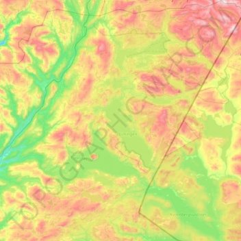
Name: Røyrvik topographic map, elevation, terrain.

Location: Røyrvik, Trøndelag, Norway (64.50304 13.03946 65.13925 14.32599)

Average elevation: 576 m

Minimum elevation: 104 m

Maximum elevation: 1,517 m

Other topographic maps

Click on a map to view its topography, its elevation and its terrain.

Nåvik

Norway > Trøndelag > Småland

Average elevation: 73 m

Fossgrenda

Norway > Trøndelag > Hovin

Average elevation: 181 m

Fannrem

Norway > Trøndelag

Average elevation: 77 m

Sør-Skokkeløya

Norway > Trøndelag

Average elevation: 11 m

Oppland

Norway > Trøndelag > Oppland

Average elevation: 204 m

Gear up for your next adventure:

🦌Outdoor Trail Camera - Monitor wildlife activity near your favorite spots
🧴First Aid Kit - Essential first aid supplies for outdoor emergencies
🪑Ultralight Camping Stool - Compact seating for rest stops during long hikes
🚲Heavy Duty Bike Lock - Secure your bike at the trailhead or during stops
🥾Light Trekking Boots - Supportive boots for multi-day treks

As an Amazon Associate, this site earns from qualifying purchases at no extra cost to you.