Geolocate

Raven topographic map

Click on the map to display elevation.

About this map

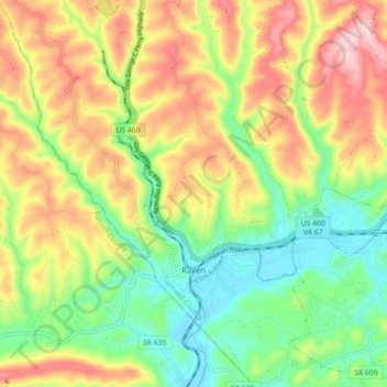
Name: Raven topographic map, elevation, terrain.

Location: Raven, Tazewell County, Virginia, United States (37.06562 -81.90015 37.13656 -81.81466)

Average elevation: 715 m

Minimum elevation: 574 m

Maximum elevation: 898 m

Other topographic maps

Click on a map to view its topography, its elevation and its terrain.

Lake Witten

United States > Virginia > Tazewell County

Average elevation: 821 m

Abbs Valley

United States > Virginia > Tazewell County

Average elevation: 844 m

Pounding Mill

United States > Virginia > Tazewell County

Average elevation: 745 m

Glen Burke

United States > Virginia > Tazewell County

Average elevation: 804 m

Tiptop

United States > Virginia > Tazewell County

Average elevation: 864 m

Stony Ridge

United States > Virginia > Tazewell County

Average elevation: 807 m

Indian

United States > Virginia > Tazewell County > Cedar Bluff

Average elevation: 681 m

Mud Fork

United States > Virginia > Tazewell County

Average elevation: 878 m

Gear up for your next adventure:

👟Trail Running Shoes - Agile footwear for fast-paced topographic exploration
❄️Traction Ice Cleats - Slip-on spikes for icy trails and winter hiking
🥤Collapsible Travel Cup - Saves space and weight in your mess kit
🧊Insulated Water Bottle - Keeps drinks cold in summer and prevents freezing in winter
🦶Anti-Blister Balm - Prevents friction and hotspots during long ascents

As an Amazon Associate, this site earns from qualifying purchases at no extra cost to you.