Geolocate

Stony Ridge topographic map

Click on the map to display elevation.

About this map

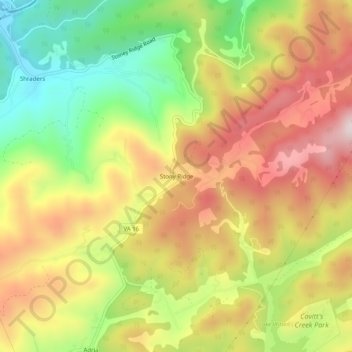
Name: Stony Ridge topographic map, elevation, terrain.

Location: Stony Ridge, Tazewell County, Virginia, 24604, United States (37.16845 -81.55372 37.20845 -81.51372)

Average elevation: 807 m

Minimum elevation: 541 m

Maximum elevation: 1,062 m

Other topographic maps

Click on a map to view its topography, its elevation and its terrain.

Tazewell

United States > Virginia > Tazewell County

Average elevation: 805 m

Lake Witten

United States > Virginia > Tazewell County

Average elevation: 821 m

Raven

United States > Virginia > Tazewell County

Average elevation: 715 m

Gear up for your next adventure:

🥾Waterproof Trail Shoes - Shoes designed to handle wet terrain
🧴Waterproofing Spray - Restore the DWR coating on jackets and tents
🧣Merino Neck Gaiter - Protects against wind, sun, and cold at high altitudes
🧭Orienteering Kit - Tools for map reading and navigation in the wild
🎒Fully Waterproof Backpack - Total protection for photography gear and electronics

As an Amazon Associate, this site earns from qualifying purchases at no extra cost to you.