Geolocate

Lake Witten topographic map

Click on the map to display elevation.

About this map

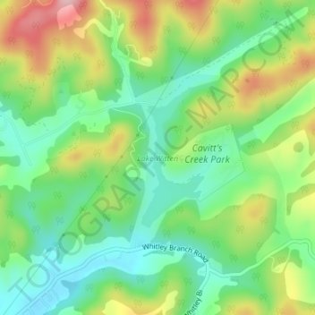
Name: Lake Witten topographic map, elevation, terrain.

Location: Lake Witten, Tazewell County, Virginia, United States (37.16566 -81.52159 37.17777 -81.51481)

Average elevation: 821 m

Minimum elevation: 744 m

Maximum elevation: 949 m

Other topographic maps

Click on a map to view its topography, its elevation and its terrain.

Tazewell

United States > Virginia > Tazewell County

Average elevation: 805 m

Abbs Valley

United States > Virginia > Tazewell County

Average elevation: 844 m

Pounding Mill

United States > Virginia > Tazewell County

Average elevation: 745 m

Raven

United States > Virginia > Tazewell County

Average elevation: 715 m

Glen Burke

United States > Virginia > Tazewell County

Average elevation: 804 m

Tiptop

United States > Virginia > Tazewell County

Average elevation: 864 m

Stony Ridge

United States > Virginia > Tazewell County

Average elevation: 807 m

Indian

United States > Virginia > Tazewell County > Cedar Bluff

Average elevation: 681 m

Mud Fork

United States > Virginia > Tazewell County

Average elevation: 878 m

Gear up for your next adventure:

🚲MTB Frame Bag - Carry tools and maps directly on your bicycle frame
💧Hydration Bladder - Hands-free hydration solution for long treks
🥾Lightweight Hiking Shoes - Comfortable shoes for day hikes
🧰Emergency Multi-Tool - Compact multi-tool for outdoor survival
🧢Hiking Sun Hat - Wide-brimmed protection for exposed mountain ridges

As an Amazon Associate, this site earns from qualifying purchases at no extra cost to you.