Geolocate

Hooe Lake topographic map

Click on the map to display elevation.

About this map

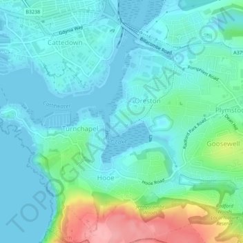
Name: Hooe Lake topographic map, elevation, terrain.

Location: Hooe Lake, Oreston, Plymouth, England, PL9 9RE, United Kingdom (50.35630 -4.11475 50.36115 -4.10534)

Average elevation: 25 m

Minimum elevation: 0 m

Maximum elevation: 120 m

Other topographic maps

Click on a map to view its topography, its elevation and its terrain.

Elburton Village

United Kingdom > England > Plymouth

Average elevation: 49 m

Colebrook Village

United Kingdom > England > Plymouth

Average elevation: 56 m

Crownhill

United Kingdom > England > Plymouth

Average elevation: 77 m

Whitleigh Wood

United Kingdom > England > Plymouth > Crownhill

Average elevation: 69 m

Cann Woods

United Kingdom > England > Plymouth

Average elevation: 57 m

Plympton

United Kingdom > England > Plymouth

Average elevation: 70 m

Gear up for your next adventure:

🥤Collapsible Travel Cup - Saves space and weight in your mess kit
🧊Portable Cooler - Keep food and drinks cold during outdoor adventures
🥾All-Terrain Hiking Boots - Versatile boots for varied hiking conditions
🧣Merino Neck Gaiter - Protects against wind, sun, and cold at high altitudes
🧦Outdoor Socks - Durable socks designed for hiking and outdoor sports

As an Amazon Associate, this site earns from qualifying purchases at no extra cost to you.