Geolocate

Colebrook Village topographic map

Click on the map to display elevation.

About this map

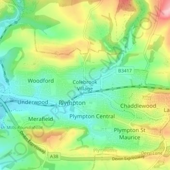
Name: Colebrook Village topographic map, elevation, terrain.

Location: Colebrook Village, Plymouth, England, PL7 4AL, United Kingdom (50.37392 -4.07379 50.41392 -4.03379)

Average elevation: 56 m

Minimum elevation: 0 m

Maximum elevation: 156 m

Other topographic maps

Click on a map to view its topography, its elevation and its terrain.

Plymouth Hoe

United Kingdom > England > Plymouth

Average elevation: 12 m

Hooe Lake

United Kingdom > England > Plymouth

Average elevation: 25 m

Cann Woods

United Kingdom > England > Plymouth

Average elevation: 57 m

Devonport Park

United Kingdom > England > Plymouth

Average elevation: 15 m

Central Park

United Kingdom > England > Plymouth > Crownhill

Average elevation: 49 m

Beaumont Park

United Kingdom > England > Plymouth

Average elevation: 24 m

Mutley Park

United Kingdom > England > Plymouth

Average elevation: 54 m

Whitleigh Wood

United Kingdom > England > Plymouth > Crownhill

Average elevation: 69 m

Gear up for your next adventure:

🚲Bike Repair Kit - Essential tools for on-trail mechanical issues
🥾Approach Boots - Comfortable boots for hiking and climbing approaches
💧Reusable Water Bottle - Durable water bottles for hydration on trails
Lightweight Backpacking Tent - Compact tent for efficient hiking trips
🧶550 Survival Paracord - Versatile utility cord for emergency repairs and rigging

As an Amazon Associate, this site earns from qualifying purchases at no extra cost to you.