Geolocate

Plympton topographic map

Click on the map to display elevation.

About this map

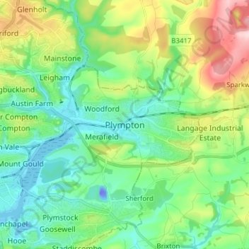
Name: Plympton topographic map, elevation, terrain.

Location: Plympton, Plymouth, England, PL7 4JR, United Kingdom (50.34982 -4.09857 50.42982 -4.01857)

Average elevation: 70 m

Minimum elevation: -38 m

Maximum elevation: 239 m

Other topographic maps

Click on a map to view its topography, its elevation and its terrain.

Beaumont Park

United Kingdom > England > Plymouth

Average elevation: 24 m

Devonport Park

United Kingdom > England > Plymouth

Average elevation: 15 m

Central Park

United Kingdom > England > Plymouth > Crownhill

Average elevation: 49 m

Whitleigh Wood

United Kingdom > England > Plymouth > Crownhill

Average elevation: 69 m

Cann Woods

United Kingdom > England > Plymouth

Average elevation: 57 m

Plymouth Hoe

United Kingdom > England > Plymouth

Average elevation: 12 m

Hooe Lake

United Kingdom > England > Plymouth

Average elevation: 25 m

Mutley Park

United Kingdom > England > Plymouth

Average elevation: 54 m

Gear up for your next adventure:

Camping Groundsheet - Protect your tent from moisture and dirt
🛶Canoe Life Vest - Safety vest for water sports
🧦Crew Hiking Socks - Comfortable socks for long-distance hikes
🧥Waterproof Hiking Jacket - Protect yourself from rain and wind while hiking
🔨Vehicle Emergency Tool - Safety tool for remote road trips to trailheads

As an Amazon Associate, this site earns from qualifying purchases at no extra cost to you.