Geolocate

Crownhill topographic map

Click on the map to display elevation.

About this map

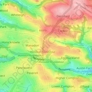
Name: Crownhill topographic map, elevation, terrain.

Location: Crownhill, Plymouth, England, PL6 5AP, United Kingdom (50.38628 -4.15203 50.42628 -4.11203)

Average elevation: 77 m

Minimum elevation: 6 m

Maximum elevation: 151 m

Other topographic maps

Click on a map to view its topography, its elevation and its terrain.

Devonport Park

United Kingdom > England > Plymouth

Average elevation: 15 m

Plymouth Hoe

United Kingdom > England > Plymouth

Average elevation: 12 m

Hooe Lake

United Kingdom > England > Plymouth

Average elevation: 25 m

Cann Woods

United Kingdom > England > Plymouth

Average elevation: 57 m

Central Park

United Kingdom > England > Plymouth > Crownhill

Average elevation: 49 m

Beaumont Park

United Kingdom > England > Plymouth

Average elevation: 24 m

Mutley Park

United Kingdom > England > Plymouth

Average elevation: 54 m

Whitleigh Wood

United Kingdom > England > Plymouth > Crownhill

Average elevation: 69 m

Gear up for your next adventure:

💧Filtered Water Bottle - Safe drinking water on the go
🧦Outdoor Socks - Durable socks designed for hiking and outdoor sports
🧥Softshell Hiking Jacket - The perfect balance of wind protection and breathability
💧Reusable Water Bottle - Durable water bottles for hydration on trails
💡LED Headlamp - Hands-free illumination for night hiking and camping

As an Amazon Associate, this site earns from qualifying purchases at no extra cost to you.