
Springdale topographic map
Click on the map to display elevation.
About this map
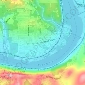
Name: Springdale topographic map, elevation, terrain.
Average elevation: 273 m
Minimum elevation: 223 m
Maximum elevation: 409 m
Other topographic maps
Click on a map to view its topography, its elevation and its terrain.
Keown Station
United States > Pennsylvania > Allegheny County > Ross Township
Average elevation: 344 m
Champion
United States > Pennsylvania > Allegheny County > North Fayette Township
Average elevation: 360 m
Tortilla Flats
United States > Pennsylvania > Allegheny County > Sewickley Heights
Average elevation: 333 m
Coraopolis Heights
United States > Pennsylvania > Allegheny County > Findlay Township
Average elevation: 320 m
Central Highlands
United States > Pennsylvania > Allegheny County > Elizabeth Township
Average elevation: 327 m
Sturgeon
United States > Pennsylvania > Allegheny County > North Fayette Township
Average elevation: 334 m
Highland Park Reservoir No. 2
United States > Pennsylvania > Allegheny County > Pittsburgh
Average elevation: 275 m
Allison Park
United States > Pennsylvania > Allegheny County > Hampton Township
Average elevation: 324 m
Neville Island
United States > Pennsylvania > Allegheny County > Neville Township
Average elevation: 289 m
Cochrans Mill
United States > Pennsylvania > Allegheny County > Jefferson Hills
Average elevation: 311 m
Allegheny River Lock and Dam No. 2
United States > Pennsylvania > Allegheny County > O'Hara Township
Average elevation: 268 m
Observatory Hill
United States > Pennsylvania > Allegheny County > Pittsburgh
Average elevation: 319 m
Stoneybrooke Woods
United States > Pennsylvania > Allegheny County > Cheswick
Average elevation: 283 m
Lovedale
United States > Pennsylvania > Allegheny County > Elizabeth Township
Average elevation: 298 m
Dorseyville
United States > Pennsylvania > Allegheny County > Indiana Township
Average elevation: 325 m