
Make a donation
Gear up for your next adventure:
As an Amazon Associate, this site earns from qualifying purchases at no extra cost to you.
Frick Park topographic map
Click on the map to display elevation.
Make a donation
Gear up for your next adventure:
As an Amazon Associate, this site earns from qualifying purchases at no extra cost to you.
About this map
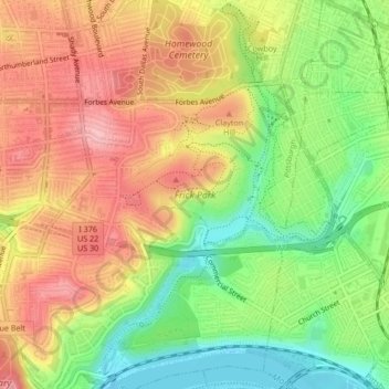
Name: Frick Park topographic map, elevation, terrain.
Average elevation: 295 m
Minimum elevation: 219 m
Maximum elevation: 365 m
Make a donation
Gear up for your next adventure:
As an Amazon Associate, this site earns from qualifying purchases at no extra cost to you.
Other topographic maps
Click on a map to view its topography, its elevation and its terrain.
Squirrel Hill South
United States > Pennsylvania > Allegheny County > Pittsburgh
Average elevation: 296 m
Make a donation
Gear up for your next adventure:
As an Amazon Associate, this site earns from qualifying purchases at no extra cost to you.
Spring Hill-City View
United States > Pennsylvania > Allegheny County > Pittsburgh
Average elevation: 292 m
Central Northside
United States > Pennsylvania > Allegheny County > Pittsburgh
Average elevation: 264 m
Make a donation
Gear up for your next adventure:
As an Amazon Associate, this site earns from qualifying purchases at no extra cost to you.
Point Breeze North
United States > Pennsylvania > Allegheny County > Pittsburgh
Average elevation: 296 m
Make a donation
Gear up for your next adventure:
As an Amazon Associate, this site earns from qualifying purchases at no extra cost to you.
Brighton Heights
United States > Pennsylvania > Allegheny County > Pittsburgh
Average elevation: 281 m
Make a donation
Gear up for your next adventure:
As an Amazon Associate, this site earns from qualifying purchases at no extra cost to you.
Observatory Hill
United States > Pennsylvania > Allegheny County > Pittsburgh
Average elevation: 319 m
California-Kirkbride
United States > Pennsylvania > Allegheny County > Pittsburgh
Average elevation: 256 m
Make a donation
Gear up for your next adventure:
As an Amazon Associate, this site earns from qualifying purchases at no extra cost to you.
Make a donation
Gear up for your next adventure:
As an Amazon Associate, this site earns from qualifying purchases at no extra cost to you.