
Make a donation
Gear up for your next adventure:
As an Amazon Associate, this site earns from qualifying purchases at no extra cost to you.
Extertal topographic map
Click on the map to display elevation.
Make a donation
Gear up for your next adventure:
As an Amazon Associate, this site earns from qualifying purchases at no extra cost to you.
Extertal
Naturräumlich wird das Gemeindegebiet zum Lipper Bergland gezählt. Das Lipper Bergland ist stark gegliedert, im Gemeindegebiet wechseln sich bis zu fast 400 Meter hohe Kuppen und Höhenzüge, Niederungen und mit Tälern eingeschnittene Hügelgebiete ab. Der Hauptort Bösingfeld liegt umgeben von mehreren Höhenzügen im Bösingfelder Becken, einer hier verbreiterten Niederung im Tal der Exter. Nach Norden öffnet sich das Tal der Exter zum Rintelner Becken. Das Gemeindegebiet liegt wie alle lippischen Kommunen im Naturpark Teutoburger Wald / Eggegebirge. Im Osten und Norden grenzt das Gemeindegebiet an den vollständig in Niedersachsen liegenden Naturpark Weserbergland Schaumburg-Hameln.
Make a donation
Gear up for your next adventure:
As an Amazon Associate, this site earns from qualifying purchases at no extra cost to you.
About this map
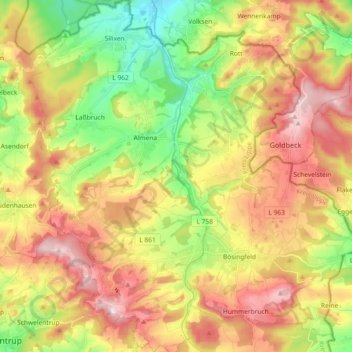
Name: Extertal topographic map, elevation, terrain.
Location: Extertal, Kreis Lippe, Nordrhein-Westfalen, 32699, Deutschland (52.03722 9.01949 52.14970 9.19403)
Average elevation: 228 m
Minimum elevation: 78 m
Maximum elevation: 389 m
Make a donation
Gear up for your next adventure:
As an Amazon Associate, this site earns from qualifying purchases at no extra cost to you.
Other topographic maps
Click on a map to view its topography, its elevation and its terrain.
Lüerdisser Bruch
Deutschland > Nordrhein-Westfalen > Kreis Lippe > Lemgo > Lüerdissen
Average elevation: 212 m
Pillenbruch
Deutschland > Nordrhein-Westfalen > Kreis Lippe > Bad Salzuflen
Südlich von Pillenbruch befindet sich der 2001/2002 errichtete Windpark Pillenbruch. Die Energiequelle GmbH betreibt hier elf Windkraftanlagen – acht NEG Micon NM60/1000 / zwei Enercon E-58 / eine Nordex N80/2500, die Windenergie in elektrische Energie (12,5 MW) umwandeln. Die jeweils rund zwei Millionen…
Average elevation: 205 m
Make a donation
Gear up for your next adventure:
As an Amazon Associate, this site earns from qualifying purchases at no extra cost to you.
Köterberg
Deutschland > Nordrhein-Westfalen > Kreis Lippe > Köterberg
Der Köterberg gehört in der naturräumlichen Haupteinheitengruppe Niedersächsisches Bergland (mit Weser- und Leine-Bergland; Nummer D36) bzw. in der Haupteinheit Lipper Bergland (364) im Südlichen Lipper Bergland (364.3) zum Naturraum Schwalenberger Höhen (364.37).
Average elevation: 334 m
Make a donation
Gear up for your next adventure:
As an Amazon Associate, this site earns from qualifying purchases at no extra cost to you.
Gauseköte
Deutschland > Nordrhein-Westfalen > Kreis Lippe > Detmold > Berlebeck
Die Passhöhe liegt im Wald des Forst Berlebeck knapp 2,5 km (Luftlinie) westlich des Oberen Langenbergs (418,8 m) mit westlich vorgelagertem Unterem Langenberg (ca. 410 m). Etwa 500 m nordnordwestlich von ihr befindet sich der Große Gauseköterberg (366,7 m) und etwa 1,7 km nordnordöstlich die Ruine…
Average elevation: 331 m
Make a donation
Gear up for your next adventure:
As an Amazon Associate, this site earns from qualifying purchases at no extra cost to you.
Blomenstein
Deutschland > Nordrhein-Westfalen > Kreis Lippe > Dörentrup > Betzen
Average elevation: 192 m
Make a donation
Gear up for your next adventure:
As an Amazon Associate, this site earns from qualifying purchases at no extra cost to you.
Make a donation
Gear up for your next adventure:
As an Amazon Associate, this site earns from qualifying purchases at no extra cost to you.
Make a donation
Gear up for your next adventure:
As an Amazon Associate, this site earns from qualifying purchases at no extra cost to you.
Heysundern
Deutschland > Nordrhein-Westfalen > Kreis Lippe > Lage > Breitenheide
Average elevation: 137 m
Vosshagen
Deutschland > Nordrhein-Westfalen > Kreis Lippe > Bad Salzuflen > Pillenbruch
Average elevation: 196 m
Make a donation
Gear up for your next adventure:
As an Amazon Associate, this site earns from qualifying purchases at no extra cost to you.
Luherheide
Deutschland > Nordrhein-Westfalen > Kreis Lippe > Lemgo > Lüerdissen
Average elevation: 170 m
Make a donation
Gear up for your next adventure:
As an Amazon Associate, this site earns from qualifying purchases at no extra cost to you.
Vogelhorst
Deutschland > Nordrhein-Westfalen > Kreis Lippe > Lemgo > Voßheide
Average elevation: 143 m
Make a donation
Gear up for your next adventure:
As an Amazon Associate, this site earns from qualifying purchases at no extra cost to you.
Make a donation
Gear up for your next adventure:
As an Amazon Associate, this site earns from qualifying purchases at no extra cost to you.
Make a donation
Gear up for your next adventure:
As an Amazon Associate, this site earns from qualifying purchases at no extra cost to you.
Stemberg
Deutschland > Nordrhein-Westfalen > Kreis Lippe > Detmold > Berlebeck
Average elevation: 266 m
Make a donation
Gear up for your next adventure:
As an Amazon Associate, this site earns from qualifying purchases at no extra cost to you.
Uhlental
Deutschland > Nordrhein-Westfalen > Kreis Lippe > Barntrup > Sonneborn
Average elevation: 237 m
Lippische Velmerstot
Deutschland > Nordrhein-Westfalen > Kreis Lippe > Leopoldstal
Average elevation: 312 m
Barnacken
Deutschland > Nordrhein-Westfalen > Kreis Lippe
Der Barnacken ist 446,4 m hoch. Auf topographischen Karten ist wenige Meter östlich des Berggipfels ein trigonometrischer Punkt auf 446,1 m Höhe und sind im Westen der Gipfelregion zwei Höhenangaben verzeichnet: 444,8 m und 442,9 m. 310 m westlich des Berggipfels liegt auf 440,8 m Höhe ein Waldwegabzweig.
Average elevation: 361 m
Make a donation
Gear up for your next adventure:
As an Amazon Associate, this site earns from qualifying purchases at no extra cost to you.
Glashütte
Deutschland > Nordrhein-Westfalen > Kreis Lippe > Schieder-Schwalenberg > Schieder
Average elevation: 214 m
Marksberg
Deutschland > Nordrhein-Westfalen > Kreis Lippe > Dörentrup > Humfeld
Average elevation: 232 m
Make a donation
Gear up for your next adventure:
As an Amazon Associate, this site earns from qualifying purchases at no extra cost to you.
Trift
Deutschland > Nordrhein-Westfalen > Kreis Lippe > Blomberg > Eschenbruch
Average elevation: 254 m
Horn-Bad Meinberg
Deutschland > Nordrhein-Westfalen > Kreis Lippe
Das von Süden nach Norden verlaufende Eggegebirge stößt bei Horn mit seinem nördlichen Ende auf das östliche Ende des von Westen nach Osten verlaufenden Teutoburger Waldes. Im Gemeindegebiet befinden sich die beiden höchsten Berge des Eggegebirges, die (auch der) Lippische Velmerstot mit 441,4 m und die…
Average elevation: 240 m
Make a donation
Gear up for your next adventure:
As an Amazon Associate, this site earns from qualifying purchases at no extra cost to you.
Lippischer Meierhof
Deutschland > Nordrhein-Westfalen > Kreis Lippe > Detmold
Average elevation: 179 m
Make a donation
Gear up for your next adventure:
As an Amazon Associate, this site earns from qualifying purchases at no extra cost to you.
Dudenhausen
Deutschland > Nordrhein-Westfalen > Kreis Lippe > Barntrup > Dudenhausen
Average elevation: 233 m
Make a donation
Gear up for your next adventure:
As an Amazon Associate, this site earns from qualifying purchases at no extra cost to you.
Make a donation
Gear up for your next adventure:
As an Amazon Associate, this site earns from qualifying purchases at no extra cost to you.
Make a donation
Gear up for your next adventure:
As an Amazon Associate, this site earns from qualifying purchases at no extra cost to you.
Köterberg
Deutschland > Nordrhein-Westfalen > Kreis Lippe > Köterberg
Der Köterberg gehört in der naturräumlichen Haupteinheitengruppe Niedersächsisches Bergland (mit Weser- und Leine-Bergland; Nummer D36) bzw. in der Haupteinheit Lipper Bergland (364) im Südlichen Lipper Bergland (364.3) zum Naturraum Schwalenberger Höhen (364.37).
Average elevation: 334 m