
Make a donation
Gear up for your next adventure:
As an Amazon Associate, this site earns from qualifying purchases at no extra cost to you.
Köterberg topographic map
Click on the map to display elevation.
Make a donation
Gear up for your next adventure:
As an Amazon Associate, this site earns from qualifying purchases at no extra cost to you.
Köterberg
Der Köterberg gehört in der naturräumlichen Haupteinheitengruppe Niedersächsisches Bergland (mit Weser- und Leine-Bergland; Nummer D36) bzw. in der Haupteinheit Lipper Bergland (364) im Südlichen Lipper Bergland (364.3) zum Naturraum Schwalenberger Höhen (364.37).
Make a donation
Gear up for your next adventure:
As an Amazon Associate, this site earns from qualifying purchases at no extra cost to you.
About this map
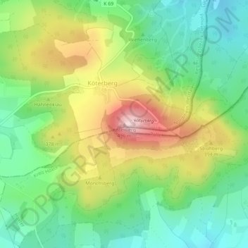
Name: Köterberg topographic map, elevation, terrain.
Location: Köterberg, Lügde, Kreis Lippe, Nordrhein-Westfalen, Deutschland (51.85534 9.32391 51.85544 9.32401)
Average elevation: 334 m
Minimum elevation: 229 m
Maximum elevation: 498 m
Make a donation
Gear up for your next adventure:
As an Amazon Associate, this site earns from qualifying purchases at no extra cost to you.