
Make a donation
Gear up for your next adventure:
As an Amazon Associate, this site earns from qualifying purchases at no extra cost to you.
Merkslohberg topographic map
Click on the map to display elevation.
Make a donation
Gear up for your next adventure:
As an Amazon Associate, this site earns from qualifying purchases at no extra cost to you.
About this map
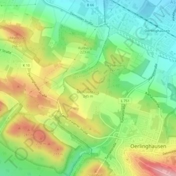
Name: Merkslohberg topographic map, elevation, terrain.
Average elevation: 209 m
Minimum elevation: 141 m
Maximum elevation: 303 m
Make a donation
Gear up for your next adventure:
As an Amazon Associate, this site earns from qualifying purchases at no extra cost to you.
Other topographic maps
Click on a map to view its topography, its elevation and its terrain.
Leopoldshöhe
Deutschland > Nordrhein-Westfalen > Kreis Lippe > Leopoldshöhe
Leopoldshöhe (plattdeutsch: Höchte) ist eine Gemeinde im Kreis Lippe. Sie liegt zentral in Ostwestfalen-Lippe, einer Region im Nordosten des Landes Nordrhein-Westfalen, und grenzt im Westen an die kreisfreie Stadt Bielefeld.
Average elevation: 119 m