
Make a donation
Gear up for your next adventure:
As an Amazon Associate, this site earns from qualifying purchases at no extra cost to you.
Tönsberg topographic map
Click on the map to display elevation.
Make a donation
Gear up for your next adventure:
As an Amazon Associate, this site earns from qualifying purchases at no extra cost to you.
About this map
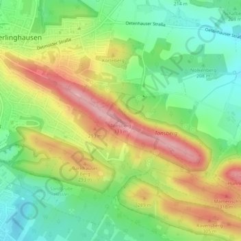
Name: Tönsberg topographic map, elevation, terrain.
Average elevation: 231 m
Minimum elevation: 161 m
Maximum elevation: 322 m
Make a donation
Gear up for your next adventure:
As an Amazon Associate, this site earns from qualifying purchases at no extra cost to you.
Other topographic maps
Click on a map to view its topography, its elevation and its terrain.
Oerlinghausen
Deutschland > Nordrhein-Westfalen > Kreis Lippe > Oerlinghausen
Die Stadt Oerlinghausen befindet sich im Westen des Kreises Lippe, im Osten Nordrhein-Westfalens. Sie liegt an einem Pass über den Höhenzug Teutoburger Wald, ungefähr in der Mitte zwischen Bielefeld (11 Kilometer westlich gelegen) und Detmold (15 Kilometer östlich gelegen) innerhalb des Naturparks…
Average elevation: 196 m