
Make a donation
Gear up for your next adventure:
As an Amazon Associate, this site earns from qualifying purchases at no extra cost to you.
Bruchberg topographic map
Click on the map to display elevation.
Make a donation
Gear up for your next adventure:
As an Amazon Associate, this site earns from qualifying purchases at no extra cost to you.
About this map
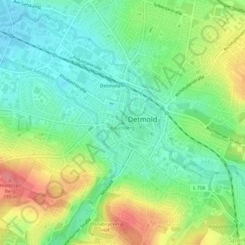
Name: Bruchberg topographic map, elevation, terrain.
Average elevation: 154 m
Minimum elevation: 124 m
Maximum elevation: 204 m
Make a donation
Gear up for your next adventure:
As an Amazon Associate, this site earns from qualifying purchases at no extra cost to you.
Other topographic maps
Click on a map to view its topography, its elevation and its terrain.
Hiddesen
Deutschland > Nordrhein-Westfalen > Kreis Lippe > Detmold
Der niedrigste Punkt des Ortes liegt am östlichen Rand im Friedenstal mit 146 m ü. NHN, in der Ortsmitte beträgt die Höhe 187 m. Am Maiweg liegt der höchste bewohnte Teil des Ortes mit 227 m, der höchste Punkt auf Hiddeser Gemarkung ist jedoch der Bielstein mit 393 Metern. Hier steht der Sender…
Average elevation: 232 m
Heiligenkirchen
Deutschland > Nordrhein-Westfalen > Kreis Lippe > Detmold
Zwischen Heiligenkirchen-Mitte und Detmold wurde mit der 1900 in Betrieb genommenen Straßenbahnlinie am Südwesthang des Büchenberges mit Blick auf das Hermannsdenkmal die Villenkolonie Friedrichshöhe errichtet, die bereits vor dem Ersten Weltkrieg mehr Villen als Heiligenkirchen Bauernhöfe aufwies.
Average elevation: 287 m
Make a donation
Gear up for your next adventure:
As an Amazon Associate, this site earns from qualifying purchases at no extra cost to you.
Make a donation
Gear up for your next adventure:
As an Amazon Associate, this site earns from qualifying purchases at no extra cost to you.