Geolocate

Fairview topographic map

Click on the map to display elevation.

About this map

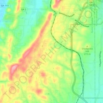
Name: Fairview topographic map, elevation, terrain.

Location: Fairview, Walker County, Georgia, United States (34.89251 -85.31945 34.95658 -85.26596)

Average elevation: 263 m

Minimum elevation: 201 m

Maximum elevation: 354 m

Other topographic maps

Click on a map to view its topography, its elevation and its terrain.

Marsh Crossing

United States > Georgia > Walker County

Average elevation: 312 m

Rock Spring

United States > Georgia > Walker County

Average elevation: 260 m

Cenchat

United States > Georgia > Walker County

Average elevation: 257 m

Yates Lake

United States > Georgia > Walker County

Average elevation: 356 m

Walnut Grove

United States > Georgia > Walker County

Average elevation: 251 m

Flintstone

United States > Georgia > Walker County

Average elevation: 258 m

Missionary Ridge

United States > Georgia > Walker County

Average elevation: 337 m

White Oak

United States > Georgia > Walker County > White Oak

Average elevation: 249 m

Gear up for your next adventure:

🎒Hiking Daypack - Lightweight and durable backpacks for day trips and excursions
🔦LED Headtorch - Bright and durable light for night activities
🧥Waterproof Jacket - Lightweight rain jackets for hiking and outdoor activities
🧦Merino Wool Socks - Moisture-wicking comfort for long-distance hiking
🧢Beanie Hat - Keep your head warm in cold weather

As an Amazon Associate, this site earns from qualifying purchases at no extra cost to you.