Geolocate

Walnut Grove topographic map

Click on the map to display elevation.

About this map

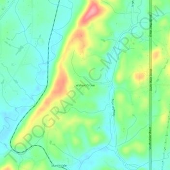
Name: Walnut Grove topographic map, elevation, terrain.

Location: Walnut Grove, Walker County, Georgia, United States (34.62175 -85.31468 34.66175 -85.27468)

Average elevation: 251 m

Minimum elevation: 217 m

Maximum elevation: 326 m

Other topographic maps

Click on a map to view its topography, its elevation and its terrain.

Lookout Mountain

United States > Georgia > Walker County

Average elevation: 406 m

Rock Spring

United States > Georgia > Walker County

Average elevation: 263 m

Fairview

United States > Georgia > Walker County

Average elevation: 263 m

Missionary Ridge

United States > Georgia > Walker County

Average elevation: 337 m

Gear up for your next adventure:

👟Trail Running Shoes - Agile footwear for fast-paced topographic exploration
🕯️Camping Lantern - Illuminates your entire campsite with high-efficiency LEDs
🔥Emergency Fire Starter - Reliable ignition source for all weather conditions
🧭GPS Handheld Device - Reliable GPS navigation for outdoor adventures
🧼Biodegradable Camp Soap - Environmentally friendly cleaning for gear and body

As an Amazon Associate, this site earns from qualifying purchases at no extra cost to you.