
Maple Ridge Township topographic map
Click on the map to display elevation.
About this map
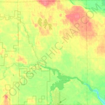
Name: Maple Ridge Township topographic map, elevation, terrain.
Location: Maple Ridge Township, Alpena County, Michigan, United States (45.07507 -83.63691 45.20710 -83.51191)
Average elevation: 214 m
Minimum elevation: 181 m
Maximum elevation: 248 m
Other topographic maps
Click on a map to view its topography, its elevation and its terrain.
Platte Lake
United States > Michigan > Benzie County
Platte Lake is located in Benzie County, which was molded into a land full of sand dunes by the glacial formations. Along with the sand dunes, the glaciers also left many lakes in the area, not only in Benzie but throughout the area. Platte Lake is located at an elevation of 584 feet (178 meters) above sea…
Average elevation: 185 m
Shelby Charter Township
United States > Michigan > Shelby Charter Township > Shelby
Average elevation: 205 m
Sinkhole
United States > Michigan > Presque Isle County > Presque Isle Township
Average elevation: 192 m
Veterans Park
United States > Michigan > Oakland County > Highland Charter Township
Average elevation: 310 m
Detroit
United States > Michigan > Wayne County
The city slopes gently from the northwest to southeast on a till plain composed largely of glacial and lake clay. The most notable topographical feature in the city is the Detroit Moraine, a broad clay ridge on which the older portions of Detroit and Windsor are located, rising approximately 62 feet (19 m)…
Average elevation: 186 m
Ray
United States > Michigan > Branch County
Ray is an unincorporated community in both Steuben County, Indiana and Branch County, Michigan in the United States. Located along the local "State Line Road," the small community straddles the border between the two states. The Indiana Northeastern Railroad travels southwest-northeast through Ray. Its…
Average elevation: 328 m
Mullet Lake Village Boating Access Site
United States > Michigan > Cheboygan County
Average elevation: 185 m