Geolocate

Long Point topographic map

Click on the map to display elevation.

About this map

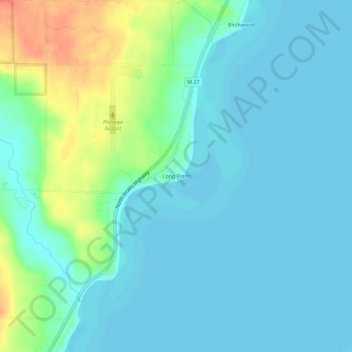
Name: Long Point topographic map, elevation, terrain.

Location: Long Point, Mullett Township, Cheboygan County, Michigan, United States (45.50140 -84.56809 45.54140 -84.52809)

Average elevation: 186 m

Minimum elevation: 175 m

Maximum elevation: 221 m

Other topographic maps

Click on a map to view its topography, its elevation and its terrain.

Cheboygan

United States > Michigan > Cheboygan County

Average elevation: 181 m

Indian River

United States > Michigan > Cheboygan County

Average elevation: 196 m

Gear up for your next adventure:

🧼Biodegradable Camp Soap - Environmentally friendly cleaning for gear and body
📷Outdoor Action Camera - Capture high-elevation views and rugged adventures
🔦UV Flashlight - Detect minerals or specific insects in the dark
🧴Outdoor Sunscreen - High SPF protection for high-altitude UV exposure
🧴Insect Repellent - Protect yourself from bugs during outdoor adventures

As an Amazon Associate, this site earns from qualifying purchases at no extra cost to you.