Geolocate

Williams Landing topographic map

Click on the map to display elevation.

About this map

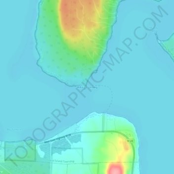
Name: Williams Landing topographic map, elevation, terrain.

Location: Williams Landing, Michigan, 49862, United States (46.43105 -86.69099 46.47105 -86.65099)

Average elevation: 190 m

Minimum elevation: 175 m

Maximum elevation: 282 m

Other topographic maps

Click on a map to view its topography, its elevation and its terrain.

Detroit River

United States > Michigan > Wayne County > Detroit

The Detroit River is only 0.5–2.5 miles (0.8–4.0 km) wide. It begins with an east-to-west flow from Lake St. Clair, but curves and runs north to south. The deepest portion of the Detroit River is 53 feet (16.2 m) in its northern portion. At its source, the river is at an elevation of 574 feet (175 m) above…

Average elevation: 183 m

Saranac

United States > Michigan > Ionia County

Average elevation: 210 m

Otsego County

United States > Michigan

Average elevation: 372 m

Huron County

United States > Michigan

Average elevation: 200 m

Attica Township

United States > Michigan > Lapeer County

Average elevation: 271 m

South Manitou Island

United States > Michigan

Average elevation: 193 m

Montmorency County

United States > Michigan

Average elevation: 293 m

Saginaw County

United States > Michigan

According to the U.S. Census Bureau, the county has a total area of 816 square miles (2,110 km2), of which 800 square miles (2,100 km2) is land and 16 square miles (41 km2) (1.9%) is water. It is part of the Flint/Tri-Cities region of Mid-Michigan. The median elevation in Saginaw County, Michigan is 620 feet…

Average elevation: 193 m

Delta County

United States > Michigan

Average elevation: 210 m

Clearwater Township

United States > Michigan

Average elevation: 232 m

Jerome Township

United States > Michigan

Average elevation: 199 m

Maple Ridge Township

United States > Michigan

Average elevation: 214 m

Penn Township

United States > Michigan

Average elevation: 276 m

Claybanks Township

United States > Michigan

Average elevation: 208 m

Charleston Township

United States > Michigan

Average elevation: 276 m

Butman Township

United States > Michigan

Average elevation: 260 m

Blood Lake

United States > Michigan

Average elevation: 325 m

Calhoun County

United States > Michigan

Average elevation: 286 m

Huron River

United States > Michigan

Average elevation: 257 m

Muskegon River

United States > Michigan

Average elevation: 301 m

Lake Township

United States > Michigan

Average elevation: 182 m

Bay County

United States > Michigan

Average elevation: 187 m

Cass County

United States > Michigan

Average elevation: 256 m

St. Joseph River

United States > Michigan

Average elevation: 257 m

Laurium

United States > Michigan > Houghton County

Average elevation: 366 m

Grand River

United States > Michigan

The Grand River is a major tributary of Lake Michigan. It falls in elevation from 1260 ft. in the highlands of its headwaters to 577 ft. at its mouth on Lake Michigan. Its waters drain northward through the lake, then south and east through the Great Lakes waterways into the St. Lawrence River, which flows…

Average elevation: 264 m

Elba Township

United States > Michigan > Lapeer County

Average elevation: 263 m

Platte Lake

United States > Michigan > Benzie County

Platte Lake is located in Benzie County, which was molded into a land full of sand dunes by the glacial formations. Along with the sand dunes, the glaciers also left many lakes in the area, not only in Benzie but throughout the area. Platte Lake is located at an elevation of 584 feet (178 meters) above sea…

Average elevation: 185 m

Standish

United States > Michigan > Arenac County

Average elevation: 190 m

Otter Lake

United States > Michigan > Genesee County

Average elevation: 263 m

Hillsdale

United States > Michigan > Hillsdale County

Average elevation: 346 m

Lake Linden

United States > Michigan > Houghton County

Average elevation: 206 m

Benton Harbor

United States > Michigan > Berrien County

Average elevation: 186 m

West Branch

United States > Michigan > Ogemaw County

Average elevation: 250 m

White Lake

United States > Michigan > Calhoun County

Average elevation: 287 m

Fruitport

United States > Michigan > Muskegon County

Average elevation: 189 m

Ely Township

United States > Michigan > Marquette County

Average elevation: 450 m

Au Gres

United States > Michigan > Arenac County

Average elevation: 179 m

Sims Township

United States > Michigan > Arenac County

Average elevation: 178 m

Skiff Lake

United States > Michigan > Jackson County

Average elevation: 308 m

Rose Lake

United States > Michigan > Shiawassee County

Average elevation: 261 m

Edgemont Park

United States > Michigan > Ingham County

Average elevation: 261 m

Lake Lapeer

United States > Michigan > Lapeer County > Hadley

Average elevation: 268 m

White Cloud

United States > Michigan > Newaygo County

Average elevation: 267 m

Beulah

United States > Michigan > Benzie County

Average elevation: 200 m

Days River

United States > Michigan > Delta County

Average elevation: 288 m

Watson

United States > Michigan > Allegan County

Average elevation: 242 m

Perry

United States > Michigan > Shiawassee County

Average elevation: 270 m

Clawson

United States > Michigan > Oakland County

Average elevation: 206 m

Hartford

United States > Michigan > Van Buren County

Average elevation: 204 m

City of Auburn

United States > Michigan > Bay County

Average elevation: 189 m

City of Essexville

United States > Michigan > Bay County

Average elevation: 180 m

East Tawas

United States > Michigan > Iosco County

Average elevation: 179 m

Corunna

United States > Michigan > Shiawassee County

Average elevation: 233 m

Coleman

United States > Michigan > Midland County

Average elevation: 231 m

Athens

United States > Michigan > Calhoun County

Average elevation: 271 m

Sylvan Lake

United States > Michigan > Oakland County

Average elevation: 287 m

Stevensville

United States > Michigan > Berrien County

Average elevation: 193 m

Sherwood

United States > Michigan > Branch County

Average elevation: 271 m

Platte Township

United States > Michigan > Benzie County

Average elevation: 249 m

Almira Township

United States > Michigan > Benzie County

Average elevation: 262 m

Lake Township

United States > Michigan > Benzie County

Average elevation: 192 m

Freeport

United States > Michigan > Barry County

Average elevation: 245 m

Nashville

United States > Michigan > Barry County

Average elevation: 256 m

Woodland

United States > Michigan > Barry County

Average elevation: 266 m

Benzonia

United States > Michigan > Benzie County

Average elevation: 216 m

Elberta

United States > Michigan > Benzie County

Average elevation: 187 m

L'Anse

United States > Michigan > Baraga County

Average elevation: 224 m

Baraga

United States > Michigan > Baraga County

Average elevation: 203 m

Gear up for your next adventure:

🥾Trekking Boots - Durable boots for long-distance trekking
Camping Coffee Maker - Brew fresh coffee anywhere on the topographic map
💧Collapsible Water Bottle - Space-saving water bottle for outdoor activities
🥾Approach Shoes - Shoes designed for climbing approaches and rugged trails
🛶Kayak Accessories - Essential gear for safe and fun kayaking adventures

As an Amazon Associate, this site earns from qualifying purchases at no extra cost to you.