Geolocate

Ada Township topographic map

Click on the map to display elevation.

About this map

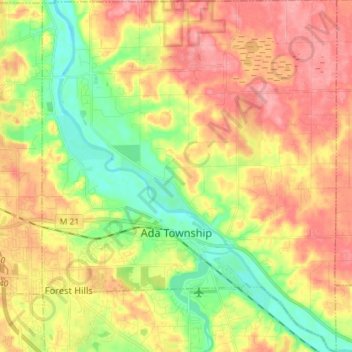
Name: Ada Township topographic map, elevation, terrain.

Location: Ada Township, Kent County, Michigan, United States (42.92397 -85.55101 43.02874 -85.43070)

Average elevation: 228 m

Minimum elevation: 180 m

Maximum elevation: 274 m

Other topographic maps

Click on a map to view its topography, its elevation and its terrain.

Kentwood

United States > Michigan > Kent County > Kentwood

Average elevation: 218 m

Alton

United States > Michigan > Kent County > Vergennes Township

Average elevation: 254 m

Cordes Lake

United States > Michigan > Kent County

Average elevation: 275 m

Scram Lake

United States > Michigan > Kent County

Average elevation: 270 m

Lake Leota

United States > Michigan > Kent County > Walker

Average elevation: 199 m

Alaska

United States > Michigan > Kent County

Average elevation: 230 m

Alto

United States > Michigan > Kent County

Average elevation: 252 m

Ada

United States > Michigan > Kent County

Average elevation: 208 m

Gear up for your next adventure:

🥾Mountaineering Boots - Supportive boots for climbing and high-altitude hiking
🎒Hiking Daypack - Lightweight and durable backpacks for day trips and excursions
🥾Mountain Hiking Shoes - Shoes with superior grip for mountainous terrain
🥤Collapsible Travel Cup - Saves space and weight in your mess kit
🥾Mountain Trail Shoes - High-traction shoes for mountain trails

As an Amazon Associate, this site earns from qualifying purchases at no extra cost to you.