
McDowell topographic map
Click on the map to display elevation.
About this map
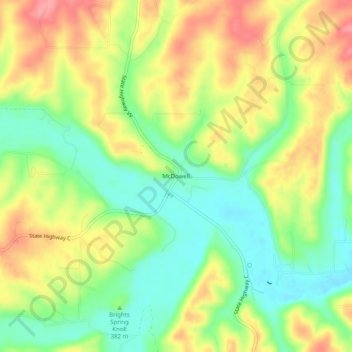
Name: McDowell topographic map, elevation, terrain.
Location: McDowell, Barry County, Missouri, United States (36.80423 -93.81326 36.84423 -93.77326)
Average elevation: 385 m
Minimum elevation: 341 m
Maximum elevation: 434 m
Other topographic maps
Click on a map to view its topography, its elevation and its terrain.
Purdy
United States > Missouri > Barry County
US Department of the Interior Original Surveys and USGS Topographical map showing the Butterfield Overland Mail Route
Average elevation: 445 m
Seligman
United States > Missouri > Barry County
Seligman is located in the Ozarks and is, bordered by the Mark Twain National Forest to the east. The town is located on a ridge along Missouri Route 37. Rainfall west of the railroad flows into the Grand Lake o' the Cherokees by way of Big Sugar Creek and Cowskin River. Rainfall to the east of Seligman flows…
Average elevation: 467 m
Purdy
United States > Missouri > Barry County
US Department of the Interior Original Surveys and USGS Topographical map showing the Butterfield Overland Mail Route
Average elevation: 445 m