Geolocate

Purdy topographic map

Click on the map to display elevation.

Purdy

US Department of the Interior Original Surveys and USGS Topographical map showing the Butterfield Overland Mail Route

Wikipedia (CC-BY-SA 3.0)

About this map

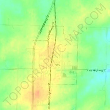
Name: Purdy topographic map, elevation, terrain.

Location: Purdy, Barry County, Missouri, 65734, United States (36.81245 -93.92789 36.82683 -93.91373)

Average elevation: 445 m

Minimum elevation: 425 m

Maximum elevation: 461 m

Other topographic maps

Click on a map to view its topography, its elevation and its terrain.

McDowell

United States > Missouri > Barry County

Average elevation: 385 m

Eagle Rock

United States > Missouri > Barry County

Average elevation: 322 m

Gear up for your next adventure:

🎒Backpack Rain Cover - External shield to keep your entire pack dry
🥽Outdoor Goggles - Protective eyewear for outdoor activities
🥾Hiking Boots - Sturdy boots providing ankle support and traction on rugged trails
🧥Softshell Jacket - Windproof and breathable jacket for hiking
🧴Waterproofing Spray - Restore the DWR coating on jackets and tents

As an Amazon Associate, this site earns from qualifying purchases at no extra cost to you.