Geolocate

Monett topographic map

Click on the map to display elevation.

About this map

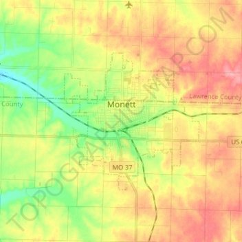
Name: Monett topographic map, elevation, terrain.

Location: Monett, Barry County, Missouri, 65708, United States (36.89243 -94.01485 36.95074 -93.88651)

Average elevation: 418 m

Minimum elevation: 370 m

Maximum elevation: 462 m

Other topographic maps

Click on a map to view its topography, its elevation and its terrain.

McDowell

United States > Missouri > Barry County

Average elevation: 385 m

Eagle Rock

United States > Missouri > Barry County

Average elevation: 322 m

Gear up for your next adventure:

🧥Thermal Layer - Insulating layer for cold outdoor conditions
🗺️Topographic Maps - Detailed maps to explore trails, mountains, and wilderness areas
🛁Quick-Dry Microfiber Towel - Space-saving towel that dries rapidly on the move
Camping Essentials - All-in-one gear for a comfortable camping trip
Family Camping Tent - Spacious tent suitable for family camping trips

As an Amazon Associate, this site earns from qualifying purchases at no extra cost to you.