Geolocate

Saillon topographic map

Click on the map to display elevation.

About this map

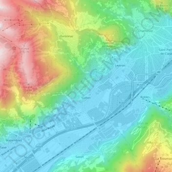
Name: Saillon topographic map, elevation, terrain.

Location: Saillon, Martigny, Wallis, 1913, Switzerland (46.15537 7.09463 46.19808 7.20515)

Average elevation: 975 m

Minimum elevation: 460 m

Maximum elevation: 2,333 m

Other topographic maps

Click on a map to view its topography, its elevation and its terrain.

Ly

Switzerland > Wallis > Martigny > Trient

Average elevation: 2,234 m

Dugny

Switzerland > Wallis > Martigny > Ovronnaz

Average elevation: 1,074 m

Le Guercet

Switzerland > Wallis > Martigny > Martigny

Average elevation: 718 m

La Tzoumaz

Switzerland > Wallis > Martigny

Average elevation: 1,467 m

Gear up for your next adventure:

💧Filtered Water Bottle - Safe drinking water on the go
🥤Collapsible Travel Cup - Saves space and weight in your mess kit
🥾Trekking Boots - Durable boots for long-distance trekking
🧰Multitool Knife - Compact and versatile tool for outdoor use
🔋Emergency Crank Radio - Weather alerts and power without needing batteries

As an Amazon Associate, this site earns from qualifying purchases at no extra cost to you.