
Make a donation
Gear up for your next adventure:
As an Amazon Associate, this site earns from qualifying purchases at no extra cost to you.
Chosendo topographic map
Click on the map to display elevation.
Make a donation
Gear up for your next adventure:
As an Amazon Associate, this site earns from qualifying purchases at no extra cost to you.
About this map
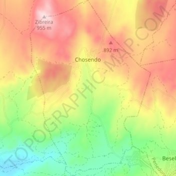
Name: Chosendo topographic map, elevation, terrain.
Location: Chosendo, Sernancelhe, Viseu, Portugal (40.93756 -7.47597 40.98333 -7.43427)
Average elevation: 774 m
Minimum elevation: 600 m
Maximum elevation: 946 m
Make a donation
Gear up for your next adventure:
As an Amazon Associate, this site earns from qualifying purchases at no extra cost to you.
Other topographic maps
Click on a map to view its topography, its elevation and its terrain.
Make a donation
Gear up for your next adventure:
As an Amazon Associate, this site earns from qualifying purchases at no extra cost to you.
Make a donation
Gear up for your next adventure:
As an Amazon Associate, this site earns from qualifying purchases at no extra cost to you.
Make a donation
Gear up for your next adventure:
As an Amazon Associate, this site earns from qualifying purchases at no extra cost to you.
Casal de Cima
Portugal > Viseu > Vilar de Besteiros e Mosteiro de Fráguas > Vilar de Besteiros > Casal de Cima
Average elevation: 338 m
Pedreles
Portugal > Viseu > Fornos de Maceira Dão > Fornos de Maceira Dão > Pedreles
Average elevation: 447 m
Make a donation
Gear up for your next adventure:
As an Amazon Associate, this site earns from qualifying purchases at no extra cost to you.