
Thank you for supporting this site ❤️
Make a donation
Make a donation
Gear up for your next adventure:
As an Amazon Associate, this site earns from qualifying purchases at no extra cost to you.
Adopisco topographic map
Click on the map to display elevation.
Thank you for supporting this site ❤️
Make a donation
Make a donation
Gear up for your next adventure:
As an Amazon Associate, this site earns from qualifying purchases at no extra cost to you.
About this map
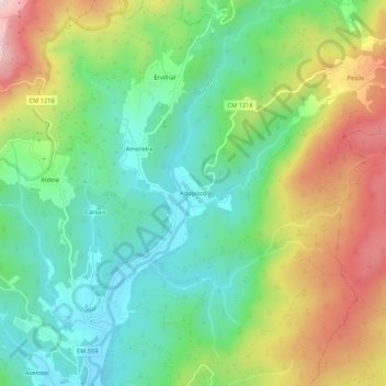
Name: Adopisco topographic map, elevation, terrain.
Location: Adopisco, Sul, São Pedro do Sul, Viseu, 3660-628, Portugal (40.82769 -8.04821 40.86769 -8.00821)
Average elevation: 392 m
Minimum elevation: 221 m
Maximum elevation: 687 m
Thank you for supporting this site ❤️
Make a donation
Make a donation
Gear up for your next adventure:
As an Amazon Associate, this site earns from qualifying purchases at no extra cost to you.