Geolocate

Bitorajci topographic map

Click on the map to display elevation.

About this map

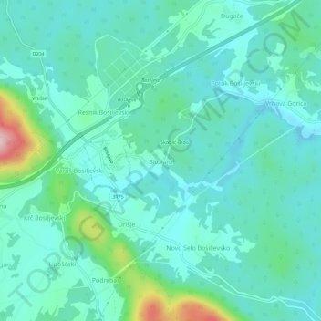
Name: Bitorajci topographic map, elevation, terrain.

Location: Bitorajci, Općina Bosiljevo, Karlovac County, 47251, Croatia (45.39214 15.27765 45.43214 15.31765)

Average elevation: 213 m

Minimum elevation: 169 m

Maximum elevation: 398 m

Other topographic maps

Click on a map to view its topography, its elevation and its terrain.

Općina Netretić

Croatia > Karlovac County

Average elevation: 198 m

Gear up for your next adventure:

🛌Insulated Sleeping Pad - Critical thermal barrier between you and the cold ground
💧Hydration Bladder - Hands-free hydration solution for long treks
🥾Trail Running Shoes - Lightweight and durable shoes for trail running
🥾Waterproof Hiking Shoes - Durable shoes for wet and rugged trails
🥾Lightweight Hiking Boots - Boots for comfort and mobility on long hikes

As an Amazon Associate, this site earns from qualifying purchases at no extra cost to you.